
Bogota Capital District - Municipality topographic map
Interactive map
Click on the map to display elevation.
Bogota Capital District - Municipality
Bogotá is located in the southeastern part of the Bogotá savanna (Sabana de Bogotá) at an average altitude of 2,640 meters (8,660 ft) above sea level. The Bogotá savanna is popularly called "savannah" (sabana), but constitutes actually a high plateau in the Andes mountains, part of an extended region known as the Altiplano Cundiboyacense, which literally means "high plateau of Cundinamarca and Boyacá". Bogotá is the largest city in the world at its elevation; there is no urban area that is both higher and more populous than Bogotá.
About this map
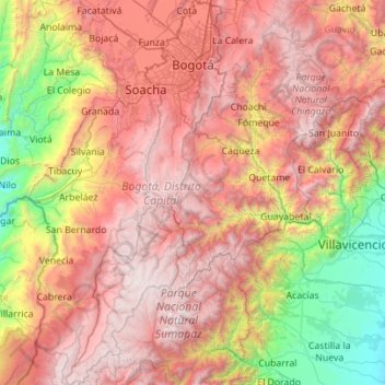
Name: Bogota Capital District - Municipality topographic map, elevation, terrain.
Average elevation: 2,183 m
Minimum elevation: 308 m
Maximum elevation: 4,222 m
Other topographic maps
Click on a map to view its topography, its elevation and its terrain.
Valledupar
Valledupar is located southeast of the Sierra Nevada de Santa Marta. Its average temperature is 28 °C. Because of its relatively high altitude and proximity to the equator, it has a variety of environments, from warm heat to perpetual snow. Notable geographic features in Valledupar include the Sierra Nevada…
Average elevation: 1,087 m
Ibagué
Ibagué features a tropical rainforest climate under the Köppen climate classification, albeit a relatively cooler version of the climate due to the high altitude. Although the city does experience noticeably drier conditions during and around the months of January and July, the city has no true dry season…
Average elevation: 1,907 m
Cali
Colombia > Valle del Cauca > Cali
Under Köppen's climate classification, Cali features a dry-summer tropical savanna climate (Köppen climate classification: As), closely bordering a tropical monsoon climate (Köppen: Am). The Western Mountain Range rises from an average of 2,000 m (6,562 ft) above sea level in the northern part of the city…
Average elevation: 1,142 m
Centro Experimental Gaviotas
Gaviotas has leveraged many forms of solar energy. They developed solar heating panels to provide hot water, which were installed in Gaviotas homes and housing developments in Medellín. The original design was not suited for Bogotá, however, since at 2,600 meters of altitude (9,000 ft) the city has a cooler…
Average elevation: 176 m
Sierra Nevada del Cocuy
The Sierra Nevada del Cocuy region corresponds to the highest elevations of the Eastern Cordillera of the Colombian Andes. The geologic origins of this mountain range are complex, but have been hypothesized to be the inversion of a Mesozoic extensional basin which gave way to a sedimentary basin that…
Average elevation: 2,041 m
Paipa
Paipa is located 15 km west of Duitama and 48 kilometres (30 mi) to the northeast of Tunja, the capital of the department, in the Cordillera Oriental (Eastern Ranges) of the Colombian Andes. It is the main tourist center of the region, with a number of large hotels and hot springs. At an elevation of 2525 m,…
Average elevation: 2,829 m
Perímetro Urbano Cúcuta
Colombia > Norte de Santander > Cúcuta
The city is in the eastern part of the Department of North Santander, in the Cordillera Oriental, close to the border with Venezuela. The city's area is 110 square kilometres (42 square miles) and its elevation is 320 metres (1,050 feet) above sea level.
Average elevation: 314 m
Perimetro Urbano Pereira
Pereira is located on the central mountain range, on the Otún river valley, and part of the Cauca river valley. Pereira, like many Colombian cities, has high-elevation areas with difficult access or flat or steep parts. The streets are laid out according to the elevation of the respective zones.
Average elevation: 1,486 m
Fusagasugá
It was founded in 1592 by Spanish priests. The town located some 56 kilometers from the capital, Bogotá; borders Pasca, Arbeláez, Tibacuy, Silvania and other municipalities of Sumapaz. Its elevation is 5,669 feet (1,728 m) above sea level, and the average temperature 20 °C (68 °F).
Average elevation: 2,130 m
Bogota, Capital District
Bogotá is located in the southeastern part of the Bogotá savanna (Sabana de Bogotá) at an average altitude of 2,640 meters (8,660 ft) above sea level. The Bogotá savanna is popularly called "savannah" (sabana), but constitutes actually a high plateau in the Andes mountains, part of an extended region known…
Average elevation: 2,183 m
Perímetro Urbano Valledupar
Colombia > Cesar > Valledupar
Valledupar is located southeast of the Sierra Nevada de Santa Marta. Its average temperature is 28 °C. Because of its relatively high altitude and proximity to the equator, it has a variety of environments, from warm heat to perpetual snow. Notable geographic features in Valledupar include the Sierra Nevada…
Average elevation: 163 m
Manizales
Colombia > Caldas > Manizales > Manizales
Manizales is the capital city of one of the smallest Colombian departments. The city is described as having an "abrupt topography", and lies on the Colombian Central Mountain Range (part of the longest continental mountain range, the Andes), with a great deal of ridgelines and steep slopes, which, combined…
Average elevation: 1,933 m
Medellín
Medellín has 16 comunas (districts), 5 corregimientos (townships), and 271 barrios (neighborhoods). The metropolitan area of Medellín lies within the Aburrá valley at an elevation of 1,500 meters (4,900 feet) above sea level and is bisected by the Medellín River (also called Porce), which flows northward.…
Average elevation: 2,094 m
Armenia
Armenia has a territorial area of 29,743 square kilometres (11,484 sq mi). The terrain is mostly mountainous, with fast flowing rivers, and few forests. The land rises to 4,090 metres (13,419 feet) above sea level at Mount Aragats, and no point is below 390 metres (1,280 ft) above sea level. Average elevation…
Average elevation: 1,709 m
Santa Catalina
Colombia > Archipiélago de San Andrés, Providencia y Santa Catalina
Average elevation: 8 m