Geolocate

Vetas topographic map

Click on the map to display elevation.

About this map

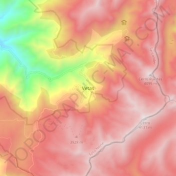
Name: Vetas topographic map, elevation, terrain.

Location: Vetas, Soto Norte, Santander, Colombia (7.26926 -72.91181 7.34926 -72.83181)

Average elevation: 3,559 m

Minimum elevation: 2,405 m

Maximum elevation: 4,145 m

Gear up for your next adventure:

🔥Camping Stove - Portable stoves to cook outdoors with ease
🚑Survival Whistle - Signal for help across long distances in mountains
🥾Trekking Poles - Adjustable trekking poles to reduce knee stress and improve stability
🥘Camping Cookware Set - Compact nesting pots and pans for trail cooking
🥾Hiking Boots - Sturdy boots providing ankle support and traction on rugged trails

As an Amazon Associate, this site earns from qualifying purchases at no extra cost to you.