
Valledupar topographic map
Click on the map to display elevation.
Valledupar
Valledupar is located southeast of the Sierra Nevada de Santa Marta. Its average temperature is 28 °C. Because of its relatively high altitude and proximity to the equator, it has a variety of environments, from warm heat to perpetual snow. Notable geographic features in Valledupar include the Sierra Nevada de Santa Marta's peaks; the Codazzi, El Guardian, the Ojeda and La Reina. Many rivers descend from its snowy peaks and lagoons; the Ariguani, Ariguanicito, Badillo, Calderas, Cesar, Curiba, Donachui, Garupal, Guatapuri, which borders the city of Valledupar; and the Mariangola.
About this map
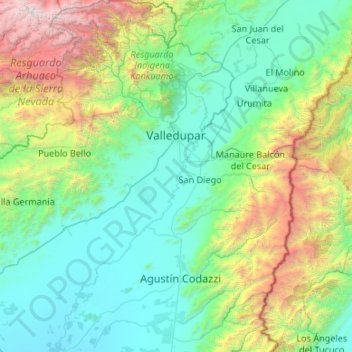
Name: Valledupar topographic map, elevation, terrain.
Location: Valledupar, Cesar, RAP Caribe, Colombia (9.81861 -73.83836 10.86762 -73.07661)
Average elevation: 1,087 m
Minimum elevation: 46 m
Maximum elevation: 5,612 m
Other topographic maps
Click on a map to view its topography, its elevation and its terrain.