
Sierra Nevada del Cocuy topographic map
Interactive map
Click on the map to display elevation.
About this map
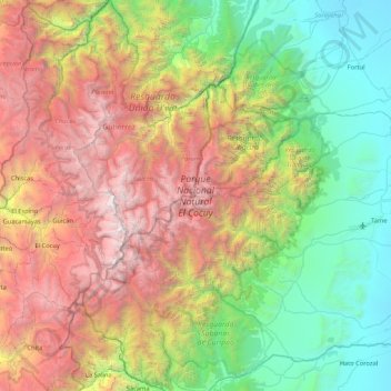
Name: Sierra Nevada del Cocuy topographic map, elevation, terrain.
Location: Sierra Nevada del Cocuy, Arauca, Colombia (6.09363 -72.47288 6.93726 -71.83167)
Average elevation: 2,041 m
Minimum elevation: 187 m
Maximum elevation: 5,303 m
The Sierra Nevada del Cocuy region corresponds to the highest elevations of the Eastern Cordillera of the Colombian Andes. The geologic origins of this mountain range are complex, but have been hypothesized to be the inversion of a Mesozoic extensional basin which gave way to a sedimentary basin that accumulated sediments for millions of years before its closure in the Paleogene. The inversion and resulting shortening and compression values have been estimated to be in the order of 60 ± 20 km. Additionally, it has been proposed that the relatively high topography of the Eastern Cordillera of the Colombian Andes around these areas is due to flat slab subduction of the Nazca plate under the South American plate for ~7.5 Million years .