
Make a donation
Gear up for your next adventure:
As an Amazon Associate, this site earns from qualifying purchases at no extra cost to you.
Ibagué topographic map
Click on the map to display elevation.
Make a donation
Gear up for your next adventure:
As an Amazon Associate, this site earns from qualifying purchases at no extra cost to you.
Ibagué
Ibagué features a tropical rainforest climate under the Köppen climate classification, albeit a relatively cooler version of the climate due to the high altitude. Although the city does experience noticeably drier conditions during and around the months of January and July, the city has no true dry season month, as all twelve months see on average more than 60 mm (2.4 in) of rain. As is commonplace in areas with this climate, temperatures are relatively consistent throughout the course of the year in Ibagué, with average high temperatures of about 28 °C or 82.4 °F and average low temperatures of about 18 °C or 64.4 °F. On average Ibagué sees 1,700 mm (66.9 in) of rain annually.
Make a donation
Gear up for your next adventure:
As an Amazon Associate, this site earns from qualifying purchases at no extra cost to you.
About this map
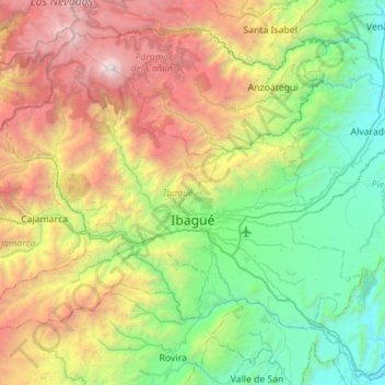
Name: Ibagué topographic map, elevation, terrain.
Location: Ibagué, Centro, Tolima, RAP (Especial) Central, Colombia (4.25786 -75.52470 4.69933 -74.96675)
Average elevation: 1,907 m
Minimum elevation: 308 m
Maximum elevation: 5,213 m
Make a donation
Gear up for your next adventure:
As an Amazon Associate, this site earns from qualifying purchases at no extra cost to you.
Other topographic maps
Click on a map to view its topography, its elevation and its terrain.
Volcán Nevado del Ruiz
The summit of the volcano has steep slopes inclining from 20 to 30 degrees. At lower elevations, the slopes become less steep; their inclination is about 10 degrees. From there on, foothills stretch almost to the edge of the Magdalena River, north of the volcano and the Cauca River to the west. On the two…
Average elevation: 5,119 m
Make a donation
Gear up for your next adventure:
As an Amazon Associate, this site earns from qualifying purchases at no extra cost to you.
Make a donation
Gear up for your next adventure:
As an Amazon Associate, this site earns from qualifying purchases at no extra cost to you.
Cordillera Central
The Cauca Valley montane forests ecoregion covers the western slope of the range. The Magdalena Valley montane forests cover the eastern slopes and the northern end of the cordillera. The Northern Andean páramo covers the highest elevations.
Average elevation: 3,706 m
Make a donation
Gear up for your next adventure:
As an Amazon Associate, this site earns from qualifying purchases at no extra cost to you.
Volcán Nevado del Ruiz
The summit of the volcano has steep slopes inclining from 20 to 30 degrees. At lower elevations, the slopes become less steep; their inclination is about 10 degrees. From there on, foothills stretch almost to the edge of the Magdalena River, north of the volcano and the Cauca River to the west. On the two…
Average elevation: 5,119 m