
Thank you for supporting this site ❤️
Make a donation
Make a donation
Gear up for your next adventure:
As an Amazon Associate, this site earns from qualifying purchases at no extra cost to you.
Aracataca topographic map
Click on the map to display elevation.
Thank you for supporting this site ❤️
Make a donation
Make a donation
Gear up for your next adventure:
As an Amazon Associate, this site earns from qualifying purchases at no extra cost to you.
About this map
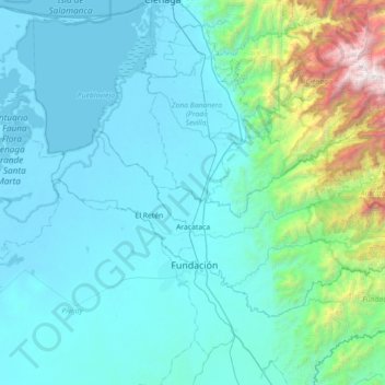
Name: Aracataca topographic map, elevation, terrain.
Location: Aracataca, Magdalena, RAP Caribe, 472001, Colombia (10.42488 -74.25745 10.87989 -73.54198)
Average elevation: 484 m
Minimum elevation: -2 m
Maximum elevation: 4,390 m
Thank you for supporting this site ❤️
Make a donation
Make a donation
Gear up for your next adventure:
As an Amazon Associate, this site earns from qualifying purchases at no extra cost to you.