
Clinton County topographic map
Click on the map to display elevation.
Clinton County
The general elevation of the county is roughly 1,050 feet (320 m) above sea level, and there are few areas in the county that deviate from this by more than 200 feet (61 m).
About this map
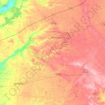
Name: Clinton County topographic map, elevation, terrain.
Location: Clinton County, Ohio, United States (39.22284 -84.00747 39.56916 -83.57629)
Average elevation: 308 m
Minimum elevation: 218 m
Maximum elevation: 366 m
Other topographic maps
Click on a map to view its topography, its elevation and its terrain.
Columbus
United States > Ohio > Franklin County > Columbus
The confluence of the Scioto and Olentangy rivers is just north-west of Downtown Columbus. Several smaller tributaries course through the Columbus metropolitan area, including Alum Creek, Big Walnut Creek, and Darby Creek. Columbus is considered to have relatively flat topography thanks to a large glacier that…
Average elevation: 255 m
Cincinnati
United States > Ohio > Hamilton County
Cincinnati has several standard modes of transportation including sidewalks, roads, public transit, bicycle paths and airports. The city's hills preclude the regular street grid common to many cities built up in the 19th century, and outside of the downtown basin, regular street grids are rare except for in…
Average elevation: 225 m
Serpent Mound
United States > Ohio > Adams County
The mound is located on the site of a classic astrobleme, an ancient meteorite impact structure. One of the strongest clues to the impact origin of this structure is in the pattern of disruption of sedimentary strata. In the center of the structure, strata have been uplifted several hundred feet, in much the…
Average elevation: 226 m
Miamisburg Community Park
United States > Ohio > Montgomery County > Miamisburg
Average elevation: 241 m
Etna
United States > Ohio > Licking County
Etna (formerly Carthage) is an unincorporated community and census-designated place (CDP) in Licking County, Ohio, United States. As of the 2020 census it had a population of 1,209. It lies at an elevation of 1,069 feet (326 m) at the intersection of U.S. Route 40 and State Route 310. It was listed as a…
Average elevation: 321 m