Geolocate

Rockbridge topographic map

Click on the map to display elevation.

About this map

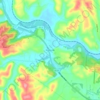
Name: Rockbridge topographic map, elevation, terrain.

Location: Rockbridge, Hocking County, Ohio, 43149, United States (39.55979 -82.54210 39.59979 -82.50210)

Average elevation: 262 m

Minimum elevation: 223 m

Maximum elevation: 329 m

Other topographic maps

Click on a map to view its topography, its elevation and its terrain.

Murray City

United States > Ohio > Hocking County

Average elevation: 257 m

Rose Lake

United States > Ohio > Hocking County

Average elevation: 295 m

Logan

United States > Ohio > Hocking County

Average elevation: 254 m

Rose Lake Dam

United States > Ohio > Hocking County

Average elevation: 297 m

Gear up for your next adventure:

🧰Emergency Multi-Tool - Compact multi-tool for outdoor survival
💧Hydration Pack - Hands-free hydration system for long hikes
👟Leg Gaiters - Keep debris, mud, and snow out of your boots
🥾Hiking Shoes - Durable and comfortable shoes for trail hiking
🚲Heavy Duty Bike Lock - Secure your bike at the trailhead or during stops

As an Amazon Associate, this site earns from qualifying purchases at no extra cost to you.