Geolocate

Byron topographic map

Click on the map to display elevation.

About this map

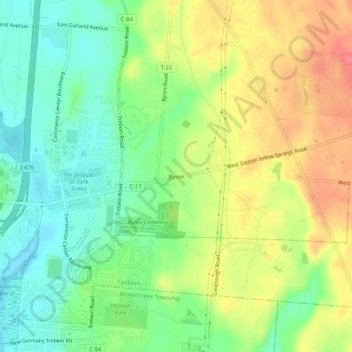
Name: Byron topographic map, elevation, terrain.

Location: Byron, Bath Township, Greene County, Ohio, 45324, United States (39.76617 -84.00077 39.80617 -83.96077)

Average elevation: 280 m

Minimum elevation: 251 m

Maximum elevation: 317 m

Other topographic maps

Click on a map to view its topography, its elevation and its terrain.

Clifton

United States > Ohio > Greene County

Average elevation: 312 m

Spring Valley

United States > Ohio > Greene County

Average elevation: 252 m

Bowersville

United States > Ohio > Greene County

Average elevation: 329 m

Bellbrook

United States > Ohio > Greene County

Average elevation: 262 m

Ross Township

United States > Ohio > Greene County

Average elevation: 330 m

Gear up for your next adventure:

💡Portable Camping Lamp - Rechargeable lamp for campsite lighting
🚲Heavy Duty Bike Lock - Secure your bike at the trailhead or during stops
🧦Crew Hiking Socks - Comfortable socks for long-distance hikes
💡Compact LED Flashlight - Powerful and portable flashlight for outdoor use
🛶Kayak Dry Bag - Waterproof storage for kayaking adventures

As an Amazon Associate, this site earns from qualifying purchases at no extra cost to you.