Geolocate

Beaumont topographic map

Click on the map to display elevation.

About this map

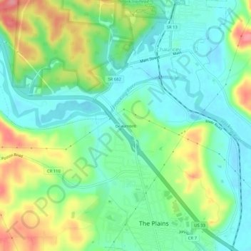
Name: Beaumont topographic map, elevation, terrain.

Location: Beaumont, Athens, Athens County, Ohio, 45780, United States (39.36563 -82.15820 39.40563 -82.11820)

Average elevation: 225 m

Minimum elevation: 192 m

Maximum elevation: 288 m

Other topographic maps

Click on a map to view its topography, its elevation and its terrain.

Pratts Fork

United States > Ohio > Athens County > Athens

Average elevation: 254 m

Gear up for your next adventure:

🥾Lightweight Hiking Shoes - Comfortable shoes for day hikes
🔋Lithium AA Batteries - Long-lasting power that performs in extreme cold
💡Portable Camping Lamp - Rechargeable lamp for campsite lighting
🥾Trekking Poles - Adjustable trekking poles to reduce knee stress and improve stability
💡Solar Camping Lamp - Eco-friendly lighting for campsites

As an Amazon Associate, this site earns from qualifying purchases at no extra cost to you.