
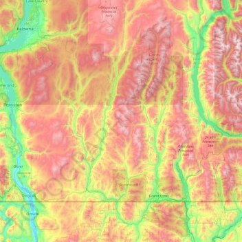
Regional District of Kootenay Boundary topographic map
Interactive map
Click on the map to display elevation.
About this map
Name: Regional District of Kootenay Boundary topographic map, elevation, terrain.
Average elevation: 1,215 m
Minimum elevation: 273 m
Maximum elevation: 2,526 m
British Columbia trails, hiking, mountain biking, running and outdoor activities
Other topographic maps
Click on a map to view its topography, its elevation and its terrain.
Stanley Park
Canada > British Columbia > Metro Vancouver Regional District > Vancouver
Average elevation: 14 m
Fairmont Hot Springs
Canada > British Columbia > Regional District of East Kootenay > Area F (Columbia Lake/Windermere Lake)
Average elevation: 920 m
Whitecroft
Canada > British Columbia > Thompson-Nicola Regional District > Area P (Rivers and the Peaks)
Average elevation: 1,000 m
Mount Cahilty
Canada > British Columbia > Thompson-Nicola Regional District > Area O (Lower North Thompson)
Average elevation: 1,736 m
North Nanaimo River
Canada > British Columbia > Regional District of Nanaimo > Area C (Arrowsmith-Benson)
Average elevation: 301 m
Beaufort Range
Canada > British Columbia > Comox Valley Regional District > Area A (Baynes Sound)
Average elevation: 435 m
Arthur Seat
Canada > British Columbia > Thompson-Nicola Regional District > Area I (Blue Sky Country)
Average elevation: 1,327 m
Elbow Lake
Canada > British Columbia > Cariboo Regional District > Area F (Horsefly/Likely/150 Mile House)
Average elevation: 959 m
Mayne
Canada > British Columbia > Capital Regional District > Southern Gulf Islands Electoral Area
Average elevation: 52 m
Map Glacier
Canada > British Columbia > Cariboo Regional District > Area J (West Chilcotin)
Average elevation: 2,037 m
Burnaby
Canada > British Columbia > Metro Vancouver Regional District > Burnaby
Burnaby occupies 98.60 square kilometres (38.07 sq mi) and is located at the geographic centre of the Metro Vancouver area and home to the Metro Vancouver regional government in Metrotown. Situated between the city of Vancouver on the west and Port Moody, Coquitlam, and New Westminster on the east, Burnaby is…
Average elevation: 144 m
Great Canyon
Canada > British Columbia > Cariboo Regional District > Area J (West Chilcotin)
Average elevation: 1,220 m
Cherryville
Canada > British Columbia > Regional District of North Okanagan > Area E (Cherryville/East Creighton)
Average elevation: 643 m
Shawnigan Lake
Canada > British Columbia > Cowichan Valley Regional District > Area B (Shawnigan Lake)
Average elevation: 128 m
Moraine Park
Canada > British Columbia > Regional District of Central Okanagan > Kelowna
Average elevation: 408 m
Kragmont
Canada > British Columbia > Regional District of East Kootenay > Area B (Lake Koocanusa)
Average elevation: 788 m
Whistler Mountain
Canada > British Columbia > Squamish-Lillooet Regional District > Whistler
There is a weather station near the summit of Whistler Mountain at the Roundhouse Lodge, located at an elevation of 1835 m (6020 ft). Whistler Roundhouse has a dry-summer subalpine climate (Köppen Dsc), bordering on an Alpine climate (Köppen ET).
Average elevation: 1,810 m
Mount Huber
Canada > British Columbia > Columbia-Shuswap Regional District > Area A (Kicking Horse/Kinbasket Lake)
Average elevation: 2,662 m
Nanoose Bay
Canada > British Columbia > Regional District of Nanaimo > Area E (Nanoose Bay)
Average elevation: 58 m
Balfour
Canada > British Columbia > Regional District of Central Kootenay > Area E (Balfour/Cottonwood Lake)
Average elevation: 673 m
Purcell Mountains
Canada > British Columbia > Regional District of East Kootenay > Area G (Forster Creek/Mount Assiniboine)
Average elevation: 2,710 m
Antler Creek
Canada > British Columbia > Cariboo Regional District > Area C (Bowron Lake/Barlow Creek/Barkerville)
Average elevation: 1,021 m
Blaeberry
Canada > British Columbia > Columbia-Shuswap Regional District > Area A (Kicking Horse/Kinbasket Lake)
Average elevation: 846 m
Whistler
Canada > British Columbia > Squamish-Lillooet Regional District > Whistler Resort Municipality > Whistler
Average elevation: 996 m
Mount Robson
Canada > British Columbia > Regional District of Fraser-Fort George > Area H (Robson Valley/Canoe)
The north face can be seen from Berg Lake, and reached by a 19 km (12 mi) hike. The lake is approximately 2 km long and lies at 1,646 m (5,400 ft) elevation. There are backcountry campgrounds at each end of the lake and a log shelter on its banks, named Hargreaves Shelter in honor of the Hargreaves family who…
Average elevation: 3,037 m
Mount Edziza
Canada > British Columbia > Regional District of Kitimat-Stikine > Area D (Iskut/Big Raven)
Mount Edziza (/ədˈzaɪzə/ əd-ZY-zə; Tahltan: Tenh Dẕetle [ten̥ ˈdðetle]) is a volcanic mountain in Cassiar Land District of northwestern British Columbia, Canada. It is located on the Big Raven Plateau of the Tahltan Highland which extends along the western side of the Stikine Plateau. Mount Edziza…
Average elevation: 2,530 m
Kamloops
Canada > British Columbia > Thompson-Nicola Regional District > Kamloops
Average elevation: 875 m
Grouse Mountain
Canada > British Columbia > Metro Vancouver Regional District
Grouse Mountain is one of the North Shore Mountains of the Pacific Ranges in the District Municipality of North Vancouver, British Columbia, Canada. With a maximum elevation of over 1,200 m (4,100 feet) at its peak, the mountain is the site of an alpine ski area, Grouse Mountain Resort, which overlooks Greater…
Average elevation: 968 m
Babine Range
Canada > British Columbia > Regional District of Bulkley-Nechako > Area A (Hudson Bay Mountain)
Average elevation: 1,893 m
Mount Juno
Canada > British Columbia > Cariboo Regional District > Area J (West Chilcotin)
Average elevation: 2,219 m
Englishman River Falls
Canada > British Columbia > Regional District of Nanaimo > Area F (Alberni Highway)
Average elevation: 198 m
Mount Curran
Canada > British Columbia > Comox Valley Regional District > Area A (Baynes Sound)
Average elevation: 1,142 m
Crow's Nest
Canada > British Columbia > Capital Regional District > Metchosin
Average elevation: 305 m
Rocky Mountains
Canada > British Columbia > Peace River Regional District > Area E (Moberly Lake/Sukunka Valley)
Average elevation: 1,462 m
Cascade Mountains
Canada > British Columbia > Regional District of Okanagan-Similkameen > Area B (Cawston/Lower Similkameen)
Average elevation: 1,207 m
Glenora
Canada > British Columbia > Cowichan Valley Regional District > Area E (Cowichan Station / Sahtlam / Glenora)
Average elevation: 80 m
Mount Sloan
Canada > British Columbia > Squamish-Lillooet Regional District > Area A (Upper Bridge River Valley)
Average elevation: 2,089 m
Sandspit
Canada > British Columbia > North Coast Regional District > Area E (Moresby Island)
Average elevation: 13 m
Lindell Beach
Canada > British Columbia > Fraser Valley Regional District > Area H (Cultus Lake/Columbia Valley)
Average elevation: 268 m
Silvertip Mountain
Canada > British Columbia > Columbia-Shuswap Regional District > Area A (Kicking Horse/Kinbasket Lake)
Average elevation: 2,443 m
Whitehorn Mountain
Canada > British Columbia > Regional District of Fraser-Fort George > Area H (Robson Valley/Canoe)
Average elevation: 2,553 m
Erickson
Canada > British Columbia > Regional District of Central Kootenay > Area B (Goat River Valley)
Average elevation: 680 m
Glenora
Canada > British Columbia > Cowichan Valley Regional District > Area E (Cowichan Station / Sahtlam / Glenora)
Average elevation: 80 m
Attachie
Canada > British Columbia > Peace River Regional District > Area B (Finlay Valley/Beatton Valley)
Average elevation: 477 m
Spratt Point
Canada > British Columbia > Central Coast Regional District > Area A (Ocean Falls/Outer Coast)
Average elevation: 5 m
Cape Range
Canada > British Columbia > Central Coast Regional District > Area A (Ocean Falls/Outer Coast)
Average elevation: 300 m
Coquitlam
Canada > British Columbia > Metro Vancouver Regional District > Coquitlam
Southwest Coquitlam comprises the original core of the city, with Maillardville and Fraser River industrial sector giving way to the large residential areas of Austin Heights, colloquially referred to as "The Bump" due to its high and flat plateau topography. These older residences, with larger property…
Average elevation: 230 m
Mount Barr
Canada > British Columbia > Fraser Valley Regional District > Area D (Popkum/Bridal Falls/Wahleach)
Mount Barr is a mountain in the Skagit Range of the Cascade Mountains of southern British Columbia, Canada, located on the northeast side of Wahleach Lake and just southwest of Hope. It is a ridge highpoint with an elevation of 1,907 m (6,257 ft).
Average elevation: 1,414 m
Bowser
Canada > British Columbia > Regional District of Nanaimo > Area H (Lighthouse Country)
Average elevation: 52 m
Allison Lake
Canada > British Columbia > Regional District of Okanagan-Similkameen > Area H (Manning Park/Tulameen/Siwash)
Average elevation: 1,141 m
D'Arcy
Canada > British Columbia > Squamish-Lillooet Regional District > Area C (Pemberton Valley/Mount Currie/D'Arcy)
Average elevation: 461 m
Mount Fergusson
Canada > British Columbia > Squamish-Lillooet Regional District > Area A (Upper Bridge River Valley)
Average elevation: 2,156 m
Langley Township
Canada > British Columbia > Metro Vancouver Regional District > Township of Langley > Langley Township
Average elevation: 37 m
Conkle Lake
Canada > British Columbia > Regional District of Kootenay Boundary > Area E (Beaverdell/West Boundary)
Average elevation: 1,221 m
Mount Garibaldi
Canada > British Columbia > Fraser Valley Regional District > Area F (McConnell Creek/Hatzic Prairie)
Mount Garibaldi (Squamish: Nch'ḵay̓, pronounced [n̩.ʧʼqɛˀj̰]) is a dormant stratovolcano in the Garibaldi Ranges of the Pacific Ranges in southwestern British Columbia, Canada. It has a maximum elevation of 2,678 metres (8,786 feet) and rises above the surrounding landscape on the east side of the…
Average elevation: 2,146 m
Blind Bay
Canada > British Columbia > Columbia-Shuswap Regional District > Area C (Blind Bay/Sorrento)
Average elevation: 414 m
Kitsault
Canada > British Columbia > Regional District of Kitimat-Stikine > Area A (Nass Valley/Bell Irving)
Average elevation: 155 m
Coyote Lake
Canada > British Columbia > Regional District of Fraser-Fort George > Area G (Crooked River/Parsnip)
Average elevation: 849 m
Ahousaht
Canada > British Columbia > Alberni-Clayoquot Regional District > Area C (Long Beach)
Average elevation: 14 m
Ripple Rock
Canada > British Columbia > Strathcona Regional District > Area B (Discovery Islands/Mainland Inlets)
Average elevation: 40 m
Eve Cone
Canada > British Columbia > Regional District of Kitimat-Stikine > Area D (Iskut/Big Raven)
Eve Cone, sometimes referred to as Eve's Cone, is a cinder cone in Cassiar Land District of northwestern British Columbia, Canada. It has an elevation of 1,740 metres (5,710 feet) and is one of several volcanic cones in the Desolation Lava Field at the northern end of the Big Raven Plateau. The cone is…
Average elevation: 1,607 m
Black Mountain (North Summit)
Canada > British Columbia > Metro Vancouver Regional District > West Vancouver
Average elevation: 931 m
Barge Park
Canada > British Columbia > Metro Vancouver Regional District > White Rock
Average elevation: 53 m
Anyox
Canada > British Columbia > Regional District of Kitimat-Stikine > Area A (Nass Valley/Bell Irving)
Average elevation: 110 m
Punchaw Lake
Canada > British Columbia > Regional District of Fraser-Fort George > Area C (Chilako River/Nechako)
Average elevation: 788 m
Mount Strachan
Canada > British Columbia > Regional District of East Kootenay > Area A (Upper Flathead/Elk Valley)
Average elevation: 2,198 m
Glimpse Lake
Canada > British Columbia > Thompson-Nicola Regional District > Area M (Beautiful Nicola Valley - North)
Average elevation: 1,211 m
Riondel
Canada > British Columbia > Regional District of Central Kootenay > Area A (Wynndel/Crawford Bay/Riondel)
Average elevation: 675 m
Soprano Peak
Canada > British Columbia > Squamish-Lillooet Regional District > Area B (Cayoosh/Pavilion)
Average elevation: 2,137 m
Lyall Point
Canada > British Columbia > Alberni-Clayoquot Regional District > Area C (Long Beach)
Average elevation: 1 m
Misty Icefield
Canada > British Columbia > Fraser Valley Regional District > Area F (McConnell Creek/Hatzic Prairie)
Average elevation: 1,800 m
Burnaby Lake Regional Park
Canada > British Columbia > Metro Vancouver Regional District > Burnaby
Average elevation: 51 m
Ryder Lake
Canada > British Columbia > Fraser Valley Regional District > Chilliwack
Average elevation: 255 m
Devils Thumb
Canada > British Columbia > Regional District of Kitimat-Stikine > Area D (Iskut/Big Raven)
Average elevation: 1,718 m
Mount Dalton
Canada > British Columbia > Regional District of Kitimat-Stikine > Area F (Dease Lake)
Average elevation: 1,658 m
Blue Lake
Canada > British Columbia > Cariboo Regional District > Area A (Red Bluff/Quesnel South)
Average elevation: 781 m
Macdonald Island
Canada > British Columbia > Sunshine Coast Regional District > Area A (Egmont/Pender Harbour)
Average elevation: 230 m
Devils Thumb
Canada > British Columbia > Regional District of Kitimat-Stikine > Area D (Iskut/Big Raven)
Average elevation: 1,718 m
Black Lake
Canada > British Columbia > Cariboo Regional District > Area C (Bowron Lake/Barlow Creek/Barkerville)
Average elevation: 1,705 m
Mayor Island
Canada > British Columbia > Regional District of Mount Waddington > Area A (Seymour Inlet/Knight Inlet)
Average elevation: 5 m
Columbia River
Canada > British Columbia > Regional District of Central Kootenay > Castlegar
Average elevation: 598 m
Cougar Creek Park
Canada > British Columbia > Metro Vancouver Regional District > Surrey
Average elevation: 86 m
Eve River
Canada > British Columbia > Regional District of Mount Waddington > Area D (Nimpkish Valley/Cormorant Island)
Average elevation: 571 m
Mount Sutton
Canada > British Columbia > Cowichan Valley Regional District > Area F (Cowichan Lake South / Skutz Falls)
Average elevation: 717 m
Mill Bay
Canada > British Columbia > Cowichan Valley Regional District > Area A (Mill Bay / Malahat)
Average elevation: 61 m
Tumbling NE5
Canada > British Columbia > Regional District of East Kootenay > Area G (Forster Creek/Mount Assiniboine)
Average elevation: 2,146 m
Thompson Glacier
Canada > British Columbia > Thompson-Nicola Regional District > Area B (Thompson Headwaters)
Average elevation: 2,313 m
Coast Mountains
Canada > British Columbia > North Coast Regional District > Area A (North Skeena)
Average elevation: 334 m