
Eve Cone topographic map
Click on the map to display elevation.
Eve Cone
Eve Cone, sometimes referred to as Eve's Cone, is a cinder cone in Cassiar Land District of northwestern British Columbia, Canada. It has an elevation of 1,740 metres (5,710 feet) and is one of several volcanic cones in the Desolation Lava Field at the northern end of the Big Raven Plateau. The cone is southeast of the community of Telegraph Creek in Mount Edziza Provincial Park, which is one of the largest provincial parks in British Columbia. A roughly 12-kilometre-long (7.5-mile) lava flow travelled down the northern side of the Big Raven Plateau from Eve Cone during the Holocene. It branches out into much narrower channels, the largest extending to Buckley Lake.
About this map
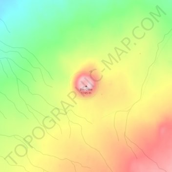
Name: Eve Cone topographic map, elevation, terrain.
Average elevation: 1,607 m
Minimum elevation: 1,483 m
Maximum elevation: 1,734 m
Regional District of Kitimat-Stikine trails, hiking, mountain biking, running and outdoor activities
Other topographic maps
Click on a map to view its topography, its elevation and its terrain.
Tumeka Lake
Canada > British Columbia > Regional District of Kitimat-Stikine > Area D (Iskut/Big Raven)
Average elevation: 1,382 m
Bob Quinn Lake
Canada > British Columbia > Regional District of Kitimat-Stikine > Area D (Iskut/Big Raven)
Average elevation: 585 m
Ball Creek
Canada > British Columbia > Regional District of Kitimat-Stikine > Area D (Iskut/Big Raven)
Average elevation: 1,228 m
Great Glacier
Canada > British Columbia > Regional District of Kitimat-Stikine > Area D (Iskut/Big Raven)
Average elevation: 866 m
Iskut River
Canada > British Columbia > Regional District of Kitimat-Stikine > Area D (Iskut/Big Raven)
Average elevation: 932 m