Geolocate

Loch Doon topographic map

Click on the map to display elevation.

About this map

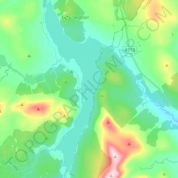
Name: Loch Doon topographic map, elevation, terrain.

Location: Loch Doon, East Ayrshire, Scotland, United Kingdom (55.20488 -4.40081 55.28572 -4.35028)

Average elevation: 291 m

Minimum elevation: 183 m

Maximum elevation: 620 m

Other topographic maps

Click on a map to view its topography, its elevation and its terrain.

Kilmarnock

United Kingdom > Scotland > East Ayrshire

Average elevation: 56 m

Crosshands

United Kingdom > Scotland > East Ayrshire

Average elevation: 122 m

Knockentiber

United Kingdom > Scotland > East Ayrshire

Average elevation: 44 m

New Cumnock

United Kingdom > Scotland > East Ayrshire

Average elevation: 275 m

Waterside

United Kingdom > Scotland > East Ayrshire

Average elevation: 168 m

Braid Wood

United Kingdom > Scotland > East Ayrshire

Average elevation: 114 m

Sinclairston

United Kingdom > Scotland > East Ayrshire

Average elevation: 169 m

Hurlford

United Kingdom > Scotland > East Ayrshire

Average elevation: 49 m

Cumnock

United Kingdom > Scotland > East Ayrshire

Average elevation: 187 m

Galston

United Kingdom > Scotland > East Ayrshire

Average elevation: 126 m

Newmilns

United Kingdom > Scotland > East Ayrshire

Average elevation: 182 m

Moscow

United Kingdom > Scotland > East Ayrshire

Average elevation: 133 m

Glenbuck Loch

United Kingdom > Scotland > East Ayrshire

Average elevation: 327 m

Hollybush

United Kingdom > Scotland > East Ayrshire

Average elevation: 129 m

Bellsbank

United Kingdom > Scotland > East Ayrshire

Average elevation: 228 m

Fenwick

United Kingdom > Scotland > East Ayrshire

Average elevation: 142 m

Stair

United Kingdom > Scotland > East Ayrshire

Average elevation: 81 m

Auchinleck

United Kingdom > Scotland > East Ayrshire

Average elevation: 147 m

Lugar

United Kingdom > Scotland > East Ayrshire

Average elevation: 182 m

Catrine

United Kingdom > Scotland > East Ayrshire

Average elevation: 139 m

Stewarton

United Kingdom > Scotland > East Ayrshire

Average elevation: 118 m

Patna

United Kingdom > Scotland > East Ayrshire

Average elevation: 209 m

Coalhall

United Kingdom > Scotland > East Ayrshire

Average elevation: 104 m

Dalmellington

United Kingdom > Scotland > East Ayrshire

Average elevation: 285 m

Mauchline

United Kingdom > Scotland > East Ayrshire

Average elevation: 125 m

Darvel

United Kingdom > Scotland > East Ayrshire

Average elevation: 214 m

Glenbuck

United Kingdom > Scotland > East Ayrshire

Average elevation: 321 m

Muirkirk

United Kingdom > Scotland > East Ayrshire

Average elevation: 261 m

Ochiltree

United Kingdom > Scotland > East Ayrshire

Average elevation: 125 m

Logan

United Kingdom > Scotland > East Ayrshire

Average elevation: 184 m

Lugton

United Kingdom > Scotland > East Ayrshire

Average elevation: 144 m

Cairnhill

United Kingdom > Scotland > East Ayrshire > Galston

Average elevation: 193 m

Gatehead

United Kingdom > Scotland > East Ayrshire

Average elevation: 32 m

Burnton

United Kingdom > Scotland > East Ayrshire > Dalmellington

Average elevation: 248 m

Lugton

United Kingdom > Scotland > East Ayrshire

Average elevation: 144 m

Dunlop

United Kingdom > Scotland > East Ayrshire

Average elevation: 132 m

Dalrymple

United Kingdom > Scotland > East Ayrshire

Average elevation: 77 m

Cumnock

United Kingdom > Scotland > East Ayrshire

Average elevation: 187 m

Kilmarnock

United Kingdom > Scotland > East Ayrshire

Average elevation: 56 m

Gear up for your next adventure:

🧰Multitool Knife - Compact and versatile tool for outdoor use
👟Leg Gaiters - Keep debris, mud, and snow out of your boots
🛶Canoe Life Vest - Safety vest for water sports
🦟Insect Repellent - Keep mosquitoes and black flies away in wooded areas
🧼Biodegradable Camp Soap - Environmentally friendly cleaning for gear and body

As an Amazon Associate, this site earns from qualifying purchases at no extra cost to you.