Geolocate

Coalhall topographic map

Click on the map to display elevation.

About this map

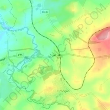
Name: Coalhall topographic map, elevation, terrain.

Location: Coalhall, East Ayrshire, Scotland, KA6 6ND, United Kingdom (55.42800 -4.48356 55.46800 -4.44356)

Average elevation: 104 m

Minimum elevation: 57 m

Maximum elevation: 182 m

Other topographic maps

Click on a map to view its topography, its elevation and its terrain.

River Doon

United Kingdom > Scotland > East Ayrshire > Dalrymple

Average elevation: 168 m

River Ayr

United Kingdom > Scotland > East Ayrshire

Average elevation: 210 m

Glenbuck Loch

United Kingdom > Scotland > East Ayrshire

Average elevation: 327 m

Braid Wood

United Kingdom > Scotland > East Ayrshire

Average elevation: 114 m

Loch Doon

United Kingdom > Scotland > East Ayrshire

Average elevation: 291 m

Gear up for your next adventure:

🧢Sun Protection Cap - Breathable cap to protect from sun exposure
🧥Softshell Jacket - Windproof and breathable jacket for hiking
Camping Coffee Maker - Brew fresh coffee anywhere on the topographic map
🧦Crew Hiking Socks - Comfortable socks for long-distance hikes
🧴Sunscreen SPF - Broad-spectrum sunscreen for outdoor activities

As an Amazon Associate, this site earns from qualifying purchases at no extra cost to you.