Geolocate

Patna topographic map

Click on the map to display elevation.

About this map

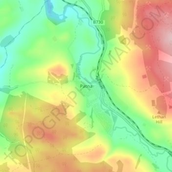
Name: Patna topographic map, elevation, terrain.

Location: Patna, East Ayrshire, Scotland, KA6 7LQ, United Kingdom (55.34376 -4.52432 55.38376 -4.48432)

Average elevation: 209 m

Minimum elevation: 119 m

Maximum elevation: 321 m

Other topographic maps

Click on a map to view its topography, its elevation and its terrain.

Braid Wood

United Kingdom > Scotland > East Ayrshire

Average elevation: 114 m

Glenbuck Loch

United Kingdom > Scotland > East Ayrshire

Average elevation: 327 m

River Doon

United Kingdom > Scotland > East Ayrshire > Dalrymple

Average elevation: 168 m

River Ayr

United Kingdom > Scotland > East Ayrshire

Average elevation: 210 m

Loch Doon

United Kingdom > Scotland > East Ayrshire

Average elevation: 291 m

Gear up for your next adventure:

🧥Thermal Fleece Jacket - Versatile insulation for changing mountain temperatures
🔦UV Flashlight - Detect minerals or specific insects in the dark
🪑Insulated Seat Pad - Protect your seat from cold rocks and wet logs
🧶550 Survival Paracord - Versatile utility cord for emergency repairs and rigging
🕯️Camping Lantern - Illuminates your entire campsite with high-efficiency LEDs

As an Amazon Associate, this site earns from qualifying purchases at no extra cost to you.