Geolocate

Mauchline topographic map

Click on the map to display elevation.

About this map

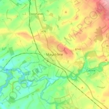
Name: Mauchline topographic map, elevation, terrain.

Location: Mauchline, East Ayrshire, Scotland, KA5 6DD, United Kingdom (55.47600 -4.41907 55.55600 -4.33907)

Average elevation: 125 m

Minimum elevation: 55 m

Maximum elevation: 241 m

Other topographic maps

Click on a map to view its topography, its elevation and its terrain.

River Doon

United Kingdom > Scotland > East Ayrshire > Dalrymple

Average elevation: 168 m

River Ayr

United Kingdom > Scotland > East Ayrshire

Average elevation: 210 m

Glenbuck Loch

United Kingdom > Scotland > East Ayrshire

Average elevation: 327 m

Braid Wood

United Kingdom > Scotland > East Ayrshire

Average elevation: 114 m

Loch Doon

United Kingdom > Scotland > East Ayrshire

Average elevation: 291 m

Gear up for your next adventure:

🛏️Camping Sleeping Mat - Comfortable mats for sleeping outdoors
🧥Thermal Fleece Jacket - Versatile insulation for changing mountain temperatures
🥾Waterproof Trail Shoes - Shoes designed to handle wet terrain
🎒Fully Waterproof Backpack - Total protection for photography gear and electronics
🧦Crew Hiking Socks - Comfortable socks for long-distance hikes

As an Amazon Associate, this site earns from qualifying purchases at no extra cost to you.