Geolocate

Muirkirk topographic map

Click on the map to display elevation.

About this map

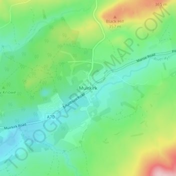
Name: Muirkirk topographic map, elevation, terrain.

Location: Muirkirk, East Ayrshire, Scotland, KA18 3RG, United Kingdom (55.50221 -4.08727 55.54221 -4.04727)

Average elevation: 261 m

Minimum elevation: 197 m

Maximum elevation: 418 m

Other topographic maps

Click on a map to view its topography, its elevation and its terrain.

River Doon

United Kingdom > Scotland > East Ayrshire > Dalrymple

Average elevation: 168 m

Braid Wood

United Kingdom > Scotland > East Ayrshire

Average elevation: 114 m

Glenbuck Loch

United Kingdom > Scotland > East Ayrshire

Average elevation: 327 m

Loch Doon

United Kingdom > Scotland > East Ayrshire

Average elevation: 291 m

River Ayr

United Kingdom > Scotland > East Ayrshire

Average elevation: 210 m

Gear up for your next adventure:

🦌Outdoor Trail Camera - Monitor wildlife activity near your favorite spots
🔥Camping Stove - Portable stoves to cook outdoors with ease
🥾Hiking Shorts - Breathable shorts suitable for summer hikes
🥾Waterproof Hiking Shoes - Durable shoes for wet and rugged trails
🧭GPS Handheld Device - Reliable GPS navigation for outdoor adventures

As an Amazon Associate, this site earns from qualifying purchases at no extra cost to you.