Geolocate

Crosshands topographic map

Click on the map to display elevation.

About this map

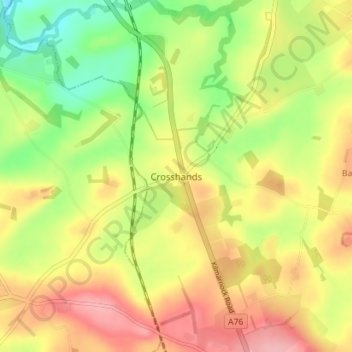
Name: Crosshands topographic map, elevation, terrain.

Location: Crosshands, East Ayrshire, Scotland, KA5 5TP, United Kingdom (55.52586 -4.42271 55.56586 -4.38271)

Average elevation: 122 m

Minimum elevation: 63 m

Maximum elevation: 177 m

Other topographic maps

Click on a map to view its topography, its elevation and its terrain.

Braid Wood

United Kingdom > Scotland > East Ayrshire

Average elevation: 114 m

Glenbuck Loch

United Kingdom > Scotland > East Ayrshire

Average elevation: 327 m

Loch Doon

United Kingdom > Scotland > East Ayrshire

Average elevation: 291 m

River Doon

United Kingdom > Scotland > East Ayrshire > Dalrymple

Average elevation: 168 m

River Ayr

United Kingdom > Scotland > East Ayrshire

Average elevation: 210 m

Gear up for your next adventure:

💡Solar Camping Lamp - Eco-friendly lighting for campsites
🕶️Polarized Sunglasses - Reduces glare from snow and water at high elevations
🎒Fully Waterproof Backpack - Total protection for photography gear and electronics
🧢Hiking Hat - Sun-protective and breathable hats for long treks
🔦UV Flashlight - Detect minerals or specific insects in the dark

As an Amazon Associate, this site earns from qualifying purchases at no extra cost to you.