Geolocate

New Cumnock topographic map

Click on the map to display elevation.

👉 Easily get elevation data in JSON, GeoTIFF and KML formats using Elevation API
Thank you for supporting this site ❤️
Make a donation

About this map

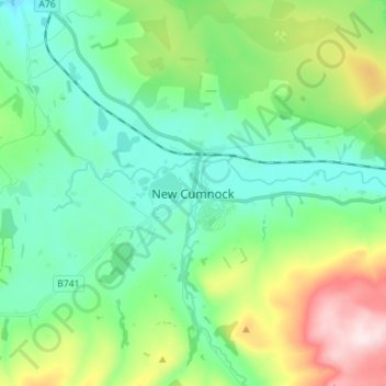
Name: New Cumnock topographic map, elevation, terrain.

Location: New Cumnock, East Ayrshire, Scotland, KA18 4AT, United Kingdom (55.35412 -4.22497 55.43412 -4.14497)

Average elevation: 275 m

Minimum elevation: 155 m

Maximum elevation: 601 m

Other topographic maps

Click on a map to view its topography, its elevation and its terrain.

Braid Wood

United Kingdom > Scotland > East Ayrshire

Average elevation: 114 m

Glenbuck Loch

United Kingdom > Scotland > East Ayrshire

Average elevation: 327 m

Loch Doon

United Kingdom > Scotland > East Ayrshire

Average elevation: 291 m

River Doon

United Kingdom > Scotland > East Ayrshire > Dalrymple

Average elevation: 168 m

River Ayr

United Kingdom > Scotland > East Ayrshire

Average elevation: 210 m

Gear up for your next adventure:

🔭Compact Monocular - One-handed bird watching and trail spotting
🧥Softshell Hiking Jacket - The perfect balance of wind protection and breathability
💧Collapsible Water Bottle - Space-saving water bottle for outdoor activities
🧳Compression Sacks - Maximize space in your backpack by shrinking gear
👖Convertible Hiking Pants - Zip-off legs to adapt to changing weather conditions

As an Amazon Associate, this site earns from qualifying purchases at no extra cost to you.