Geolocate

Bellsbank topographic map

Click on the map to display elevation.

About this map

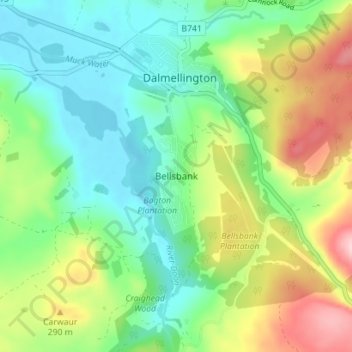
Name: Bellsbank topographic map, elevation, terrain.

Location: Bellsbank, East Ayrshire, Scotland, KA6 7TJ, United Kingdom (55.29207 -4.41770 55.33207 -4.37770)

Average elevation: 228 m

Minimum elevation: 158 m

Maximum elevation: 363 m

Other topographic maps

Click on a map to view its topography, its elevation and its terrain.

River Doon

United Kingdom > Scotland > East Ayrshire > Dalrymple

Average elevation: 168 m

River Ayr

United Kingdom > Scotland > East Ayrshire

Average elevation: 210 m

Glenbuck Loch

United Kingdom > Scotland > East Ayrshire

Average elevation: 327 m

Braid Wood

United Kingdom > Scotland > East Ayrshire

Average elevation: 114 m

Loch Doon

United Kingdom > Scotland > East Ayrshire

Average elevation: 291 m

Gear up for your next adventure:

🥾Hiking Shorts - Breathable shorts suitable for summer hikes
🔦LED Flashlight - Powerful and long-lasting flashlight for camping and emergencies
🧥Waterproof Jacket - Lightweight rain jackets for hiking and outdoor activities
🧥Ultralight Puffy Jacket - Maximum warmth that packs down to the size of an orange
🥾Approach Shoes - Shoes designed for climbing approaches and rugged trails

As an Amazon Associate, this site earns from qualifying purchases at no extra cost to you.