
Istria County topographic map
Click on the map to display elevation.
Istria County
The terrain consists of a limestone plateau much of which lacks water owing to its karst topography. The northeastern section is an extension of the Dinaric Alps. The highest point is Vojak on Učka mountain 1,401 m (4,596.46 ft) above sea level and there is another range of mountains, the Ćićarija.
About this map
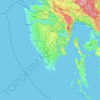
Name: Istria County topographic map, elevation, terrain.
Location: Istria County, Croatia (44.46893 13.21048 45.58838 14.25862)
Average elevation: 129 m
Minimum elevation: -5 m
Maximum elevation: 1,747 m
Other topographic maps
Click on a map to view its topography, its elevation and its terrain.
Staro Petrovo Selo
Croatia > Brod-Posavina County
It is located between the southern slopes of the Požeška gora mountain and the Sava river plain in the region of Slavonia, 12 km (7.5 mi) southeast of Nova Gradiška, at an elevation of 91 m.
Average elevation: 128 m