Make a donation
Gear up for your next adventure:
As an Amazon Associate, this site earns from qualifying purchases at no extra cost to you.
Novi Marof topographic map
Click on the map to display elevation.
Make a donation
Gear up for your next adventure:
As an Amazon Associate, this site earns from qualifying purchases at no extra cost to you.
About this map
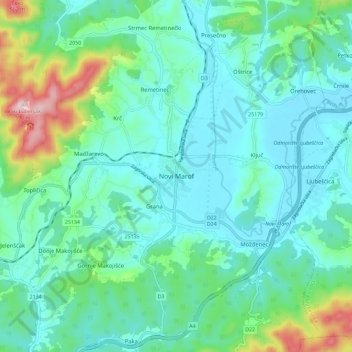
Name: Novi Marof topographic map, elevation, terrain.
Location: Novi Marof, Grad Novi Marof, Varaždin County, 42220, Croatia (46.12441 16.29478 46.20441 16.37478)
Average elevation: 253 m
Minimum elevation: 173 m
Maximum elevation: 564 m
Make a donation
Gear up for your next adventure:
As an Amazon Associate, this site earns from qualifying purchases at no extra cost to you.
Other topographic maps
Click on a map to view its topography, its elevation and its terrain.
City of Varaždin
Since records began in 1949, the highest temperature recorded at the local weather station at an elevation of 157 metres (515 ft) was 39.4 °C (102.9 °F), on 8 August 2013. The coldest temperature was −28.0 °C (−18.4 °F), on 16 February 1956.
Average elevation: 172 m
Make a donation
Gear up for your next adventure:
As an Amazon Associate, this site earns from qualifying purchases at no extra cost to you.
Make a donation
Gear up for your next adventure:
As an Amazon Associate, this site earns from qualifying purchases at no extra cost to you.
