Geolocate

Fažana topographic map

Click on the map to display elevation.

About this map

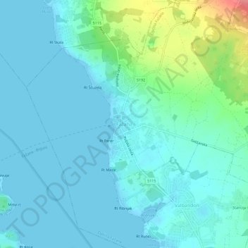
Name: Fažana topographic map, elevation, terrain.

Location: Fažana, Općina Fažana, Istria County, 52212, Croatia (44.90733 13.78508 44.94733 13.82508)

Average elevation: 15 m

Minimum elevation: -1 m

Maximum elevation: 84 m

Gear up for your next adventure:

🛰️Satellite Messenger - Emergency communication for areas with no cell service
🔭Compact Monocular - One-handed bird watching and trail spotting
🥾Trail Hiking Socks - Comfortable socks to prevent blisters and fatigue
🥾Mountain Hiking Shoes - Shoes with superior grip for mountainous terrain
🥾Trail Hiking Shoes - Durable shoes designed for rugged trails

As an Amazon Associate, this site earns from qualifying purchases at no extra cost to you.