Geolocate

Slime topographic map

Click on the map to display elevation.

About this map

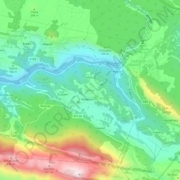
Name: Slime topographic map, elevation, terrain.

Location: Slime, Grad Omiš, Split-Dalmatia County, 21255, Croatia (43.40584 16.85619 43.44584 16.89619)

Average elevation: 236 m

Minimum elevation: 43 m

Maximum elevation: 630 m

Gear up for your next adventure:

💡LED Headlamp - Hands-free illumination for night hiking and camping
🧴Insect Repellent - Protect yourself from bugs during outdoor adventures
🥾Trail Hiking Boots - Supportive boots for rough trails
🧼Travel Hand Sanitizer - Keep hands clean when water is scarce
🐕Hiking Dog Pack - Let your canine companion carry their own water and food

As an Amazon Associate, this site earns from qualifying purchases at no extra cost to you.