Geolocate

Livade topographic map

Click on the map to display elevation.

About this map

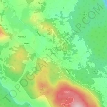
Name: Livade topographic map, elevation, terrain.

Location: Livade, Gornje Primišlje, Grad Slunj, Karlovac County, Croatia (45.13535 15.48411 45.17535 15.52411)

Average elevation: 289 m

Minimum elevation: 169 m

Maximum elevation: 482 m

Gear up for your next adventure:

Family Camping Tent - Spacious tent suitable for family camping trips
🧦Hiking Liner Socks - Thin base layer to prevent friction and blisters
🧢Hiking Hat - Sun-protective and breathable hats for long treks
🛏️Sleeping Bag - Warm and compact sleeping bags for outdoor camping
🛌Insulated Sleeping Pad - Critical thermal barrier between you and the cold ground

As an Amazon Associate, this site earns from qualifying purchases at no extra cost to you.