Geolocate

Novigrad topographic map

Click on the map to display elevation.

About this map

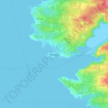
Name: Novigrad topographic map, elevation, terrain.

Location: Novigrad, Grad Novigrad, Istria County, NOVIGRAD, Croatia (45.27685 13.52495 45.35685 13.60495)

Average elevation: 17 m

Minimum elevation: -5 m

Maximum elevation: 110 m

Gear up for your next adventure:

👟Sport Hiking Sandals - Breathable footwear for water crossings and camp rest
🧦Crew Hiking Socks - Comfortable socks for long-distance hikes
💧Collapsible Water Bottle - Space-saving water bottle for outdoor activities
🧢Sun Hat - Wide-brim hat for sun protection
🔦LED Headtorch - Bright and durable light for night activities

As an Amazon Associate, this site earns from qualifying purchases at no extra cost to you.