Geolocate

Paklenica topographic map

Click on the map to display elevation.

About this map

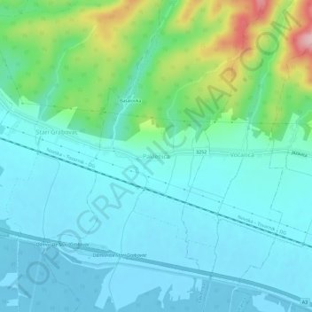
Name: Paklenica topographic map, elevation, terrain.

Location: Paklenica, Grad Novska, Sisak-Moslavina County, 44330, Croatia (45.29985 17.00441 45.33985 17.04441)

Average elevation: 133 m

Minimum elevation: 91 m

Maximum elevation: 290 m

Gear up for your next adventure:

🥫Freeze-Dried Meals - Lightweight, high-calorie nutrition for multi-day treks
🥾Approach Shoes - Shoes designed for climbing approaches and rugged trails
🎒Backpack Rain Cover - External shield to keep your entire pack dry
🔥Emergency Fire Starter - Reliable ignition source for all weather conditions
🚑Survival Whistle - Signal for help across long distances in mountains

As an Amazon Associate, this site earns from qualifying purchases at no extra cost to you.