Geolocate

Beder topographic map

Click on the map to display elevation.

About this map

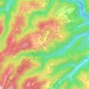
Name: Beder topographic map, elevation, terrain.

Location: Beder, Grad Samobor, Zagreb County, 10432, Croatia (45.79187 15.58928 45.83187 15.62928)

Average elevation: 414 m

Minimum elevation: 189 m

Maximum elevation: 646 m

Other topographic maps

Click on a map to view its topography, its elevation and its terrain.

Mala Jazbina

Croatia > Zagreb County > Grad Samobor

Average elevation: 234 m

Cerje Samoborsko

Croatia > Zagreb County > Grad Samobor

Average elevation: 345 m

Gear up for your next adventure:

🥽Outdoor Goggles - Protective eyewear for outdoor activities
🕶️Polarized Sunglasses - Protect your eyes with durable polarized lenses
🧣Merino Neck Gaiter - Protects against wind, sun, and cold at high altitudes
🧢Sun Protection Cap - Breathable cap to protect from sun exposure
Lightweight Camping Tent - Portable shelter optimized for Canadian backcountry camping

As an Amazon Associate, this site earns from qualifying purchases at no extra cost to you.