Geolocate

Slough topographic map

Click on the map to display elevation.

About this map

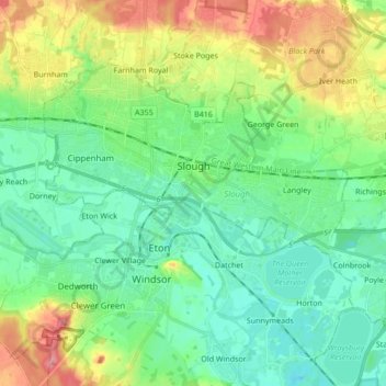
Name: Slough topographic map, elevation, terrain.

Location: Slough, England, United Kingdom (51.46798 -0.66017 51.53891 -0.49004)

Average elevation: 36 m

Minimum elevation: 10 m

Maximum elevation: 92 m

Other topographic maps

Click on a map to view its topography, its elevation and its terrain.

Chelmsford

United Kingdom > England > Essex > Chelmsford

Average elevation: 53 m

White Cliffs of Dover

United Kingdom > England > Dover

Average elevation: 51 m

Romford

United Kingdom > England

The town centre is about 50 feet (15 m) above sea level on a gravel terrace rising from the River Thames. The north of the town has developed on London Clay and is situated as much as 150 ft (46 m) above sea level. A continuous gentle rise in the eastern suburbs towards Gidea Park and Harold Wood peaks around…

Average elevation: 29 m

Burton-on-Trent

United Kingdom > England > Staffordshire > East Staffordshire

Burton is about 109 miles (175 km) north west of London, about 30 miles north east of Birmingham, the UK's second largest city and about 23 miles east of the county town Stafford. It is at the easternmost border of the county of Staffordshire with Derbyshire, its suburbs and the course of the River Trent…

Average elevation: 69 m

Ilford

United Kingdom > England

Average elevation: 16 m

Lewes Castle

United Kingdom > England > East Sussex > Lewes

Average elevation: 26 m

London

United Kingdom > England > London

Average elevation: 42 m

Paignton

United Kingdom > England > Torbay

Average elevation: 49 m

Random

United Kingdom > England > Random

Average elevation: 347 m

Conisbrough

United Kingdom > England > Doncaster

Average elevation: 61 m

Swanage Bay

United Kingdom > England

Average elevation: 15 m

Scratchy Bottom

United Kingdom > England > Dorset

Average elevation: 69 m

Dewsbury

United Kingdom > England > Kirklees

Average elevation: 91 m

Highgate

United Kingdom > England > Birmingham

Average elevation: 126 m

Ipswich

United Kingdom > England > Suffolk > Ipswich > Ipswich

Ipswich experiences an oceanic climate, like the rest of the British Isles, with a narrow range of temperature and rainfall spread evenly throughout the year. One of the two nearest for which data is available is East Bergholt, about 7 miles (11 km) south west of the town centre and at a similar elevation, and…

Average elevation: 30 m

Little Lake

United Kingdom > England > Hampshire > Havant > Langstone

Average elevation: 2 m

Harrogate

United Kingdom > England > North Yorkshire

Harrogate is situated on the edge of the Yorkshire Dales, with the Vale of York to the east and the upland Yorkshire Dales to the west and north-west. It has a dry and mild climate, typical of places in the rain shadow of the Pennines. It is on the A59 from Skipton to York. At an altitude of between 100 and…

Average elevation: 106 m

Cold Fell

United Kingdom > England > Cumberland > Castle Carrock

Average elevation: 517 m

Bagshot

United Kingdom > England > Surrey > Surrey Heath

Average elevation: 80 m

Rowley Regis

United Kingdom > England > Sandwell

Average elevation: 155 m

Norwich

United Kingdom > England > Norfolk > Norwich

Average elevation: 29 m

Leyland

United Kingdom > England > Lancashire > South Ribble

Average elevation: 41 m

Hodge Hill

United Kingdom > England > Birmingham

Average elevation: 101 m

Ennerdale Bridge

United Kingdom > England > Cumberland

Average elevation: 187 m

Great Lakes

United Kingdom > England > Great Lakes

Average elevation: 150 m

New York

United Kingdom > England > North Tyneside

Average elevation: 55 m

Coaley

United Kingdom > England > Gloucestershire > Stroud

Average elevation: 65 m

Graves Park

United Kingdom > England > Sheffield

Average elevation: 174 m

Penelopes Pond

United Kingdom > England > Surrey > Waverley > Milford

Average elevation: 59 m

Denham Green

United Kingdom > England > Suffolk > Mid Suffolk

Average elevation: 47 m

Clacton-on-Sea

United Kingdom > England > Essex > Tendring

Average elevation: 7 m

Heathfield

United Kingdom > England > East Sussex > Wealden

Average elevation: 99 m

Lea

United Kingdom > England > Wiltshire

Average elevation: 82 m

Trembraze

United Kingdom > England > Cornwall > Liskeard

Average elevation: 128 m

Seatown

United Kingdom > England > Dorset

Average elevation: 39 m

Chalk

United Kingdom > England > Kent > Gravesham

Average elevation: 27 m

Deadman's Head

United Kingdom > England > Hampshire > Havant

Average elevation: 0 m

Coverdale

United Kingdom > England > North Yorkshire > Coverham

Average elevation: 379 m

Charlton Mackrell

United Kingdom > England > Somerset

Average elevation: 42 m

Nuncargate

United Kingdom > England > Nottinghamshire > Ashfield

Average elevation: 152 m

Willenhall

United Kingdom > England

Average elevation: 143 m

Bulwell

United Kingdom > England > Nottingham

Average elevation: 84 m

Darfield

United Kingdom > England > Barnsley

Average elevation: 43 m

Packmoor

United Kingdom > England > Stoke-on-Trent

Average elevation: 194 m

Bebington

United Kingdom > England

Bebington is on the eastern side of the Wirral Peninsula, approximately 10 km (6.2 mi) south-south-east of the Irish Sea at New Brighton, about 7.5 km (4.7 mi) east-north-east of the Dee Estuary at Gayton and less than 2 km (1.2 mi) west-north-west of the River Mersey at New Ferry. The area is situated at an…

Average elevation: 28 m

Tarbock Green

United Kingdom > England > Halewood > Knowsley

Average elevation: 19 m

Water Houses

United Kingdom > England > North Yorkshire

Average elevation: 431 m

Winsor

United Kingdom > England > Hampshire > New Forest

Average elevation: 27 m

Fence

United Kingdom > England > Lancashire > Borough of Pendle

Average elevation: 187 m

Storrington

United Kingdom > England > West Sussex

Average elevation: 65 m

Seasalter

United Kingdom > England > Kent > Canterbury

Average elevation: 12 m

Flint Hill

United Kingdom > England > County Durham

Average elevation: 191 m

Woeful Hill

United Kingdom > England > Northumberland

Average elevation: 137 m

West Scholes

United Kingdom > England > Bradford > Thornton

Average elevation: 284 m

Kirk Sandall

United Kingdom > England > Doncaster

Average elevation: 9 m

Aldridge

United Kingdom > England

Average elevation: 144 m

Weybridge

United Kingdom > England > Surrey > Elmbridge

Average elevation: 21 m

Durham

United Kingdom > England > County Durham

Average elevation: 119 m

Garston

United Kingdom > England > Hertfordshire

Average elevation: 84 m

Harbledown

United Kingdom > England > Kent > Canterbury

Average elevation: 41 m

Aldershot

United Kingdom > England > Hampshire > Rushmoor

Average elevation: 92 m

Matlock

United Kingdom > England > Derbyshire > Derbyshire Dales

Average elevation: 213 m

Hoddesdon

United Kingdom > England > Hertfordshire

Average elevation: 54 m

Bramhall

United Kingdom > England

Average elevation: 82 m

Pontefract

United Kingdom > England > Wakefield

Average elevation: 41 m

Wyberton

United Kingdom > England > Lincolnshire > Boston

Average elevation: 4 m

Silbury Hill

United Kingdom > England > Wiltshire > Beckhampton

Average elevation: 166 m

Brabourne Lees

United Kingdom > England > Kent > Ashford

Average elevation: 73 m

Ludney

United Kingdom > England > Somerset > Kingstone

Average elevation: 89 m

Dalton Moor

United Kingdom > England > North Yorkshire > Dalton

Average elevation: 27 m

Gear up for your next adventure:

💧Reusable Water Bottle - Durable water bottles for hydration on trails
🧳Compression Sacks - Maximize space in your backpack by shrinking gear
🚑Survival Whistle - Signal for help across long distances in mountains
🧭Orienteering Kit - Tools for map reading and navigation in the wild
🛶Kayak Dry Bag - Waterproof storage for kayaking adventures

As an Amazon Associate, this site earns from qualifying purchases at no extra cost to you.