Geolocate

Bulwell topographic map

Click on the map to display elevation.

About this map

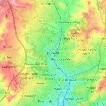
Name: Bulwell topographic map, elevation, terrain.

Location: Bulwell, Nottingham, England, NG6 8QA, United Kingdom (52.96109 -1.23718 53.04109 -1.15718)

Average elevation: 84 m

Minimum elevation: 30 m

Maximum elevation: 157 m

Gear up for your next adventure:

🛏️Camping Sleeping Mat - Comfortable mats for sleeping outdoors
🪑Insulated Seat Pad - Protect your seat from cold rocks and wet logs
🧦Hiking Liner Socks - Thin base layer to prevent friction and blisters
🔭Outdoor Binoculars - Lightweight binoculars for birdwatching and hiking
Camping Groundsheet - Protect your tent from moisture and dirt

As an Amazon Associate, this site earns from qualifying purchases at no extra cost to you.