Geolocate

Chalk topographic map

Click on the map to display elevation.

About this map

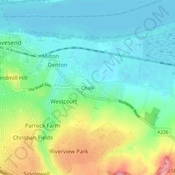
Name: Chalk topographic map, elevation, terrain.

Location: Chalk, Gravesham, Kent, England, DA12 2NQ, United Kingdom (51.41211 0.37936 51.45211 0.41936)

Average elevation: 27 m

Minimum elevation: -1 m

Maximum elevation: 94 m

Other topographic maps

Click on a map to view its topography, its elevation and its terrain.

Meopham

United Kingdom > England > Kent > Gravesham

Average elevation: 124 m

Gravesham

United Kingdom > England > Kent > Gravesham

Average elevation: 63 m

Gear up for your next adventure:

🔦LED Flashlight - Powerful and long-lasting flashlight for camping and emergencies
🎒Fully Waterproof Backpack - Total protection for photography gear and electronics
🧤Thermal Hiking Gloves - Grip-enhanced gloves for cold-weather altitude trekking
🐕Hiking Dog Pack - Let your canine companion carry their own water and food
🎒Backpack Rain Cover - External shield to keep your entire pack dry

As an Amazon Associate, this site earns from qualifying purchases at no extra cost to you.