
Harrogate topographic map
Click on the map to display elevation.
Harrogate
Harrogate is situated on the edge of the Yorkshire Dales, with the Vale of York to the east and the upland Yorkshire Dales to the west and north-west. It has a dry and mild climate, typical of places in the rain shadow of the Pennines. It is on the A59 from Skipton to York. At an altitude of between 100 and 200 metres (330 and 660 ft), Harrogate is higher than many English settlements. It has an average minimum temperature in January of slightly below 0 °C (32 °F) and an average maximum in July and August of 20 °C (68 °F).
About this map
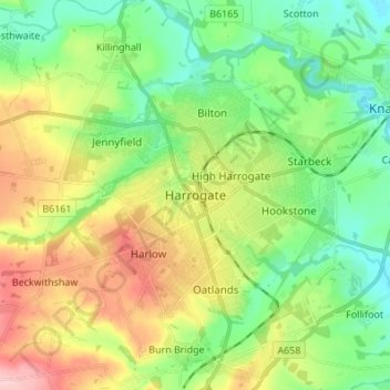
Name: Harrogate topographic map, elevation, terrain.
Location: Harrogate, North Yorkshire, England, HG1 1RD, United Kingdom (53.95215 -1.57910 54.03215 -1.49910)
Average elevation: 106 m
Minimum elevation: 40 m
Maximum elevation: 221 m
Other topographic maps
Click on a map to view its topography, its elevation and its terrain.
Scarborough
United Kingdom > England > North Yorkshire
The climate is temperate with mild summers and cool, windy, winters. The hottest months of the year are July and August, with temperatures reaching an average high of 17 °C and falling to 11 °C at night. The average daytime temperatures in January are 4 °C, falling to 1 °C at night. The station's elevation…
Average elevation: 50 m
Barton-le-Street
United Kingdom > England > North Yorkshire > Ryedale > Barton-le-Street
Average elevation: 43 m