Geolocate

London topographic map

Click on the map to display elevation.

About this map

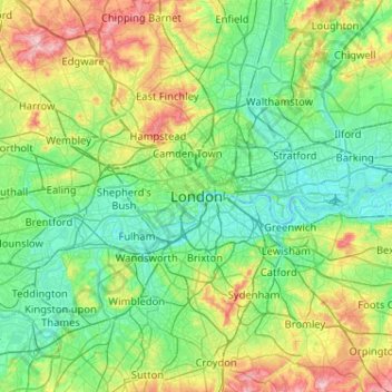
Name: London topographic map, elevation, terrain.

Location: London, Westminster, England, SW1A 2DX, United Kingdom (51.34732 -0.28765 51.66732 0.03235)

Average elevation: 42 m

Minimum elevation: -3 m

Maximum elevation: 163 m

Other topographic maps

Click on a map to view its topography, its elevation and its terrain.

Greenwich Park

United Kingdom > England > London > Greenwich

Average elevation: 22 m

Alexandra Road Park

United Kingdom > England > London

Average elevation: 48 m

Victoria Park

United Kingdom > England > London

Average elevation: 13 m

Gear up for your next adventure:

🧊Portable Cooler - Keep food and drinks cold during outdoor adventures
🥾All-Terrain Hiking Boots - Versatile boots for varied hiking conditions
🧢Sun Protection Cap - Breathable cap to protect from sun exposure
🚑Survival Whistle - Signal for help across long distances in mountains
🧰Multitool Knife - Compact and versatile tool for outdoor use

As an Amazon Associate, this site earns from qualifying purchases at no extra cost to you.