Geolocate

Ludney topographic map

Click on the map to display elevation.

About this map

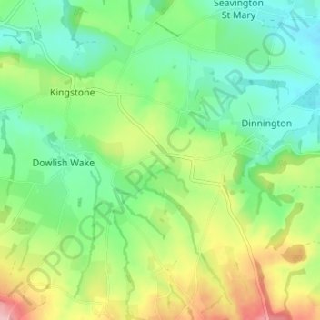
Name: Ludney topographic map, elevation, terrain.

Location: Ludney, Kingstone, Somerset, England, TA17 8TD, United Kingdom (50.88973 -2.89060 50.92973 -2.85060)

Average elevation: 89 m

Minimum elevation: 36 m

Maximum elevation: 189 m

Gear up for your next adventure:

🦌Outdoor Trail Camera - Monitor wildlife activity near your favorite spots
Lightweight Backpacking Tent - Compact tent for efficient hiking trips
🧢Beanie Hat - Keep your head warm in cold weather
🔦UV Flashlight - Detect minerals or specific insects in the dark
🧰Emergency Multi-Tool - Compact multi-tool for outdoor survival

As an Amazon Associate, this site earns from qualifying purchases at no extra cost to you.