
Chenzhou topographic map
Click on the map to display elevation.
About this map
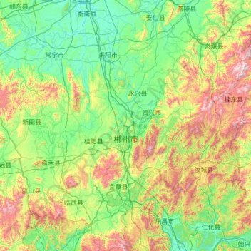
Name: Chenzhou topographic map, elevation, terrain.
Location: Chenzhou, Hunan, China (24.89368 112.22413 26.84077 114.23190)
Average elevation: 443 m
Minimum elevation: 50 m
Maximum elevation: 2,012 m
Other topographic maps
Click on a map to view its topography, its elevation and its terrain.
Zhangjiajie Tianmen Mountain National Forest Park
China > Hunan > Yongding District
Average elevation: 781 m
Zhangjiajie Tianmen Mountain National Forest Park
China > Hunan > Yongding District
Average elevation: 781 m
Ningxiang
China > Hunan > Ningxiang > Yutan Subdistrict
The highest natural elevation in Ningxiang County is 1071m at Wazizhai (瓦子寨).
Average elevation: 83 m