Geolocate

Xinpu topographic map

Click on the map to display elevation.

About this map

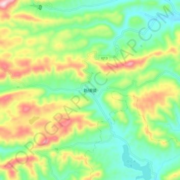
Name: Xinpu topographic map, elevation, terrain.

Location: Xinpu, Changde, Hunan, China (29.64469 111.33825 29.72469 111.41825)

Average elevation: 259 m

Minimum elevation: 95 m

Maximum elevation: 543 m

Other topographic maps

Click on a map to view its topography, its elevation and its terrain.

Li County

China > Hunan > Changde

Average elevation: 104 m

Wuling District

China > Hunan > Changde

Average elevation: 52 m

Shimen County

China > Hunan > Changde

Average elevation: 407 m

Gear up for your next adventure:

🧦Thermal Socks - Warm socks for winter hiking or camping
🎒Hiking Backpack - Lightweight and ergonomic backpacks for day hikes or multi-day treks
🥾Lightweight Hiking Shoes - Comfortable shoes for day hikes
🧭GPS Outdoor Watch - Smart watch for navigation and fitness tracking in nature
🧤Rechargeable Heated Gloves - Extreme warmth for Canadian winter expeditions

As an Amazon Associate, this site earns from qualifying purchases at no extra cost to you.