Geolocate

Cili topographic map

Click on the map to display elevation.

About this map

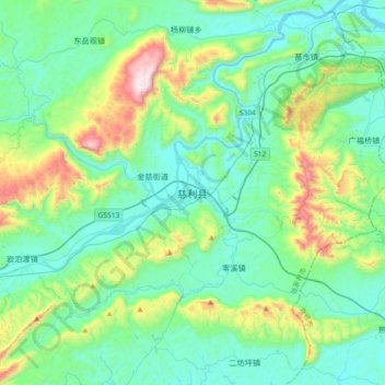
Name: Cili topographic map, elevation, terrain.

Location: Cili, Cili County, Zhangjiajie, Hunan, China (29.27274 110.97396 29.59274 111.29396)

Average elevation: 280 m

Minimum elevation: 59 m

Maximum elevation: 1,114 m

Gear up for your next adventure:

🧦Crew Hiking Socks - Comfortable socks for long-distance hikes
🧭GPS Outdoor Watch - Smart watch for navigation and fitness tracking in nature
🧊Insulated Water Bottle - Keeps drinks cold in summer and prevents freezing in winter
Backpacking Tent - Lightweight tent for long-distance hiking trips
🕶️Polarized Sunglasses - Protect your eyes with durable polarized lenses

As an Amazon Associate, this site earns from qualifying purchases at no extra cost to you.