Geolocate

Mangshan topographic map

Click on the map to display elevation.

About this map

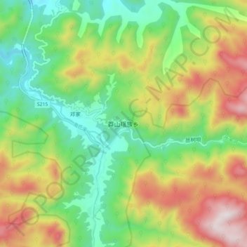
Name: Mangshan topographic map, elevation, terrain.

Location: Mangshan, Chenzhou, Hunan, China (24.95030 112.81159 25.03030 112.89159)

Average elevation: 739 m

Minimum elevation: 344 m

Maximum elevation: 1,340 m

Gear up for your next adventure:

🧰Emergency Multi-Tool - Compact multi-tool for outdoor survival
🛶Waterproof Dry Bags - Keep electronics and clothes dry during river crossings
💡LED Headlamp - Hands-free illumination for night hiking and camping
🥾Trekking Boots - Durable boots for long-distance trekking
Tent Footprint - Protect tent floor and increase durability

As an Amazon Associate, this site earns from qualifying purchases at no extra cost to you.