Geolocate

Chishi topographic map

Click on the map to display elevation.

About this map

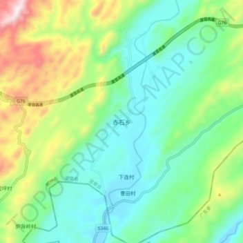
Name: Chishi topographic map, elevation, terrain.

Location: Chishi, Yizhang County, Chenzhou, Hunan, China (25.47568 113.13079 25.55568 113.21079)

Average elevation: 457 m

Minimum elevation: 233 m

Maximum elevation: 995 m

Gear up for your next adventure:

🚲MTB Frame Bag - Carry tools and maps directly on your bicycle frame
🔦LED Headlamp - Hands-free lighting for early morning starts or late finishes
🏕️Camping Hammock - Integrated protection for sleeping between trees
🎒Hiking Daypack - Lightweight and durable backpacks for day trips and excursions
Lightweight Backpacking Tent - Compact tent for efficient hiking trips

As an Amazon Associate, this site earns from qualifying purchases at no extra cost to you.