Geolocate

Matang topographic map

Click on the map to display elevation.

About this map

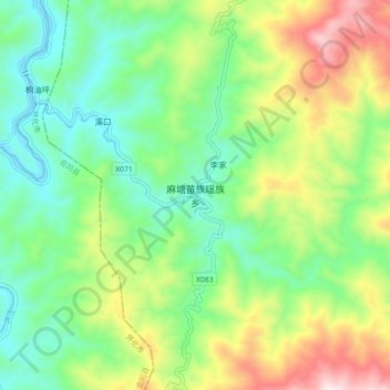
Name: Matang topographic map, elevation, terrain.

Location: Matang, Suining County, Shaoyang, Hunan, China (26.78276 110.03307 26.86276 110.11307)

Average elevation: 463 m

Minimum elevation: 213 m

Maximum elevation: 945 m

Gear up for your next adventure:

Tent Footprint - Protect tent floor and increase durability
👟Trail Running Shoes - Agile footwear for fast-paced topographic exploration
🛰️Satellite Messenger - Emergency communication for areas with no cell service
🥾Light Hiking Boots - Lightweight and comfortable boots for day hikes
🧰Multitool Knife - Compact and versatile tool for outdoor use

As an Amazon Associate, this site earns from qualifying purchases at no extra cost to you.