
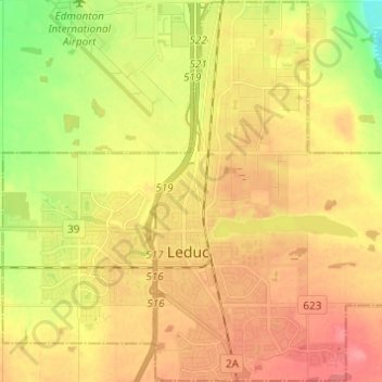
City of Leduc topographic map
Interactive map
Click on the map to display elevation.
About this map
Name: City of Leduc topographic map, elevation, terrain.
Location: City of Leduc, Alberta, Canada (53.23606 -113.61041 53.30858 -113.48842)
Average elevation: 727 m
Minimum elevation: 688 m
Maximum elevation: 756 m
Other topographic maps
Click on a map to view its topography, its elevation and its terrain.
Edmonton
Canada > Alberta > Division No. 11
Edmonton, Division No. 11, Alberta, Canada
Average elevation: 690 m
Lake Louise
Canada > Alberta > Division No. 15
Lake Louise, Division No. 15, Alberta, Canada
Average elevation: 1,617 m
Lethbridge
Canada > Alberta > Lethbridge
Lethbridge, City of Lethbridge, Alberta, T1J 4L3, Canada
Average elevation: 918 m
Nose Hill Park
Nose Hill Park, Calgary, Alberta, T3K 2P6, Canada
Average elevation: 1,174 m
Grande Prairie
Canada > Alberta > Grande Prairie
Grande Prairie, City of Grande Prairie, Alberta, T8V 2X3, Canada
Average elevation: 668 m
Fort McMurray
Canada > Alberta > Division No. 16
Fort McMurray, Division No. 16, Alberta, Canada
Average elevation: 345 m
Cypress Hills Provincial Park
Canada > Alberta > Cypress County > Elkwater
Cypress Hills Provincial Park, Elkwater, Cypress County, Alberta, T0J 1C0, Canada
Average elevation: 1,258 m
Castle Provincial Park
Canada > Alberta > Municipal District of Pincher Creek No. 9
Castle Provincial Park, Municipality of Crowsnest Pass, Municipal District of Pincher Creek No. 9, Alberta, Canada
Average elevation: 1,587 m
Jasper National Park
Jasper National Park, Alberta, T0E 1E0, Canada
Average elevation: 1,782 m
Kananaskis
Canada > Alberta > Municipal District of Bighorn > Kananaskis
Kananaskis, Municipal District of Bighorn, Alberta, T0L 2C0, Canada
Average elevation: 1,426 m
Canmore
Canada > Alberta > Division No. 15
Canmore, Division No. 15, Alberta, T1W 2H4, Canada
Average elevation: 1,565 m
Cochrane
Canada > Alberta > Town of Cochrane > Cochrane
Cochrane, Town of Cochrane, Alberta, T4V 2A7, Canada
Average elevation: 1,205 m
Bragg Creek
Bragg Creek, Census Divsion No. 6, Alberta, T0L 0K0, Canada
Average elevation: 1,384 m
Inglewood
Canada > Alberta > Division No. 11 > Edmonton
Inglewood, Western Mature Area, Edmonton, Division No. 11, Alberta, Canada
Average elevation: 671 m
Drumheller
Canada > Alberta > Division No. 5
Drumheller, Division No. 5, Alberta, T0J 0Y2, Canada
Average elevation: 763 m
Elbow River
Canada > Alberta > Rocky View County
Elbow River, Rocky View County, Alberta, Canada
Average elevation: 1,516 m
Lac des Arcs
Canada > Alberta > Division No. 15 > Lac des Arcs
Lac des Arcs, Division No. 15, Alberta, Canada
Average elevation: 1,347 m
Rolling Hills
Canada > Alberta > County of Newell
Rolling Hills, County of Newell, Alberta, Canada
Average elevation: 748 m
Thorncliff Park
Canada > Alberta > Division No. 11 > Edmonton
Thorncliff Park, Thorncliff, West Jasper Place, Edmonton, Division No. 11, Alberta, Canada
Average elevation: 677 m
Crowsnest Pass
Canada > Alberta > Crowsnest Pass
Crowsnest Pass, Municipality of Crowsnest Pass, Alberta, T0K 0M0, Canada
Average elevation: 1,410 m
Village of Innisfree
Canada > Alberta > Division No. 10
Village of Innisfree, Division No. 10, Alberta, T0B 2G0, Canada
Average elevation: 679 m
Waterton Lakes National Park
Canada > Alberta > Division No. 3
Waterton Lakes National Park, Division No. 3, Alberta, Canada
Average elevation: 1,778 m
Okotoks
Canada > Alberta > Town of Okotoks
Okotoks, Town of Okotoks, Alberta, T1S 2N7, Canada
Average elevation: 1,096 m
Clairmont
Canada > Alberta > Division No. 19 > Hamlet of Clairmont
Clairmont, Hamlet of Clairmont, Division No. 19, Alberta, T0H 0W0, Canada
Average elevation: 679 m
Brown-Lowery Provincial Park
Canada > Alberta > Foothills County
Brown-Lowery Provincial Park, Foothills County, Alberta, Canada
Average elevation: 1,353 m
Half Moon Lake
Canada > Alberta > Division No. 11
Half Moon Lake, Division No. 11, Alberta, Canada
Average elevation: 752 m
Meeting Creek
Canada > Alberta > Division No. 10
Meeting Creek, Division No. 10, Alberta, Canada
Average elevation: 763 m
Mildred Lake
Canada > Alberta > Division No. 15 > Municipality of Jasper
Mildred Lake, Municipality of Jasper, Division No. 15, Alberta, Canada
Average elevation: 1,046 m
Diamond City
Canada > Alberta > Division No. 2
Diamond City, Division No. 2, Alberta, Canada
Average elevation: 891 m
Bearspaw Dam
Bearspaw Dam, Calgary, Mountain View, Alberta, Canada
Average elevation: 1,137 m
Central McDougall Park
Canada > Alberta > Division No. 11 > Edmonton
Central McDougall Park, Central McDougall, Central Core, Edmonton, Division No. 11, Alberta, Canada
Average elevation: 666 m
Driftpile
Canada > Alberta > Division No. 17
Driftpile, Division No. 17, Alberta, Canada
Average elevation: 590 m
Chain Lakes Provincial Park
Canada > Alberta > Division No. 15
Chain Lakes Provincial Park, Division No. 15, Alberta, Canada
Average elevation: 1,365 m