Geolocate

Lawrence County topographic map

Interactive map

Click on the map to display elevation.

About this map

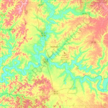
Name: Lawrence County topographic map, elevation, terrain.

Location: Lawrence County, Indiana, United States (38.68656 -86.68406 38.99240 -86.27528)

Average elevation: 203 m

Minimum elevation: 142 m

Maximum elevation: 286 m

Other topographic maps

Click on a map to view its topography, its elevation and its terrain.

Snacks

United States > Indiana > Marion County > Indianapolis

Average elevation: 244 m

Crooked Lake

United States > Indiana > Steuben County

Average elevation: 307 m

Valparaiso

United States > Indiana > Porter County

Average elevation: 235 m

Warrick County

United States > Indiana

Average elevation: 130 m

Lowell

United States > Indiana > Lake County

Average elevation: 214 m

Indiana Dunes National Park

United States > Indiana > Porter County > Portage

Miller Woods is located in Miller Beach, Indiana. It is accessed through the Paul H. Douglas Center for Environmental Education on Lake Street. The area is dominated by ridge and swale topography. the ridges or swells are beach and dune sand. They date from the post Glacial Lake Nipissing period some 3000…

Average elevation: 188 m

Wayne County

United States > Indiana

According to the 2010 census, the county has a total area of 404.34 square miles (1,047.2 km2), of which 401.74 square miles (1,040.5 km2) (or 99.36%) is land and 2.60 square miles (6.7 km2) (or 0.64%) is water. Wayne County includes Indiana's highest natural elevation, Hoosier Hill, at 1,257 feet (383 m).

Average elevation: 322 m

Nutwood

United States > Indiana > Saint Joseph County

Average elevation: 259 m

Mooresville

United States > Indiana > Morgan County

Average elevation: 223 m

Hobart

United States > Indiana > Lake County

Average elevation: 197 m

Lagro

United States > Indiana > Wabash County

Average elevation: 227 m

Floyd County

United States > Indiana

The Knobs Unit, which includes Floyd County, contains some of the hilliest country in Indiana. As a result, the area supports trees that prefer very dry sites and ridgetops, as well as those that prefer very wet sites, ravines, or “bottomland.” Tree types unique to the unit include blackjack oak and swamp…

Average elevation: 211 m

Carlson Lake

United States > Indiana > Porter County > Valparaiso

Average elevation: 250 m

Portage

United States > Indiana > Porter County

Average elevation: 190 m

Oriole Lake

United States > Indiana > Perry County

Average elevation: 211 m

French Lick

United States > Indiana > Orange County

Average elevation: 186 m

Danes

United States > Indiana > Cass County

Average elevation: 203 m

Franklin

United States > Indiana > Johnson County

Average elevation: 230 m

Rockport

United States > Indiana > Spencer County

Average elevation: 121 m

Harrison County

United States > Indiana

Average elevation: 205 m

Michigan City

United States > Indiana > LaPorte County

Average elevation: 188 m

Slough Creek

United States > Indiana > Jasper County

Average elevation: 206 m

Orange County

United States > Indiana

Average elevation: 210 m

Bloomington

United States > Indiana > Monroe County

Bloomington is an area of irregular limestone terrain characterized by sinks, ravines, fissures, underground streams, sinking streams, springs and caves. It is in the rolling hills of southern Indiana, resting on the intersection of the Norman Uplands and the Mitchell Plain. The city's relatively varied…

Average elevation: 241 m

LaPorte County

United States > Indiana

Average elevation: 219 m

Galveston

United States > Indiana > Cass County

Average elevation: 246 m

Madison

United States > Indiana > Madison

Average elevation: 227 m

Griffith

United States > Indiana > Lake County

Average elevation: 190 m

Kosciusko County

United States > Indiana

Average elevation: 262 m

Warren County

United States > Indiana

According to the 2010 census, the county has a total area of 366.40 square miles (949.0 km2), of which 364.68 square miles (944.5 km2) (or 99.53%) is land and 1.72 square miles (4.5 km2) (or 0.47%) is water. Elevations in the county range from 480 feet (150 m) above sea level where the Wabash River enters…

Average elevation: 208 m

Perry County

United States > Indiana

Average elevation: 166 m

Allen County

United States > Indiana

Average elevation: 246 m

Fish Creek

United States > Indiana > LaPorte County > Fish Lake

Average elevation: 217 m

Jeffersonville

United States > Indiana > Clark County

Average elevation: 150 m

Brownsburg

United States > Indiana > Hendricks County

Average elevation: 271 m

Wells County

United States > Indiana

Average elevation: 255 m

Ripley County

United States > Indiana > Ripley County

Average elevation: 279 m

Merrillville

United States > Indiana > Lake County > Merrillville

Average elevation: 204 m

Fort Wayne

United States > Indiana > Allen County

The first settlement started in 1815. In 1819, the military garrison abandoned the fort and moved to Detroit. In 1822, a federal land office opened to sell land ceded by local Native Americans by the Treaty of St. Mary's in 1818. Platted in 1823 at the Ewing Tavern, the village became an important frontier…

Average elevation: 246 m

Sullivan

United States > Indiana > Sullivan County > Sullivan > Sullivan

Average elevation: 153 m

Grafton

United States > Indiana > Posey County

Average elevation: 120 m

Alert

United States > Indiana > Decatur County > Alert

Average elevation: 232 m

Carmel

United States > Indiana > Hamilton County

Average elevation: 253 m

Muncie

United States > Indiana > Delaware County

Average elevation: 291 m

West Lafayette

United States > Indiana > Tippecanoe County

West Lafayette lies in central Tippecanoe County and overlooks the Wabash River, which borders the city on the east and south. Most of the city lies in eastern Wabash Township, though a small portion on the northeast side extends into Tippecanoe Township. Elevations range from slightly over 500 feet (150 m)…

Average elevation: 192 m

Taggart

United States > Indiana > Brown County > Taggart

Average elevation: 237 m

Indianapolis

United States > Indiana > Indianapolis

Indianapolis is within the Tipton Till Plain, a flat to gently sloping terrain underlain by glacial deposits known as till. The lowest point in the city is about 650 feet (198 m) above mean sea level, with the highest natural elevation at about 900 feet (274 m) above sea level. Few hills or short ridges, known…

Average elevation: 241 m