Geolocate

Sullivan topographic map

Click on the map to display elevation.

About this map

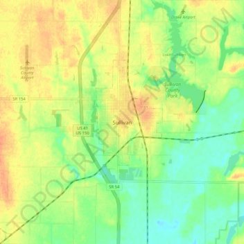
Name: Sullivan topographic map, elevation, terrain.

Location: Sullivan, Sullivan County, Indiana, 47882, United States (39.05526 -87.44778 39.13526 -87.36778)

Average elevation: 153 m

Minimum elevation: 133 m

Maximum elevation: 172 m

Gear up for your next adventure:

🥾Mountain Hiking Boots - High-traction boots for rocky terrain
🧥Thermal Layer - Insulating layer for cold outdoor conditions
Backpacking Tent - Lightweight tent for long-distance hiking trips
💡LED Camping Lantern - Illuminate your campsite with long-lasting lanterns
🥾Trail Hiking Socks - Comfortable socks to prevent blisters and fatigue

As an Amazon Associate, this site earns from qualifying purchases at no extra cost to you.