Geolocate

Warren County topographic map

Click on the map to display elevation.

Warren County

According to the 2010 census, the county has a total area of 366.40 square miles (949.0 km2), of which 364.68 square miles (944.5 km2) (or 99.53%) is land and 1.72 square miles (4.5 km2) (or 0.47%) is water. Elevations in the county range from 480 feet (150 m) above sea level where the Wabash River enters Vermillion County to 830 feet (250 m) in northeastern Prairie Township. The landscape consists mostly of flat or gently sloping moraine overlaying silty and loamy glacial till, except along the Wabash River where sand, gravel, sandstone and shale are exposed. Various forms of silt loam constitute most of the county's soil and are conducive to agriculture. Forests cover about 14% of the county, mainly around major waterways, and consist principally of deciduous hardwoods among which maple–beech and oak–hickory forests are the most common. The only coal mines in the county are located in the southeastern part of Steuben Township, near the Wabash River.

Wikipedia (CC-BY-SA 3.0)

About this map

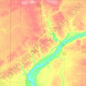
Name: Warren County topographic map, elevation, terrain.

Location: Warren County, Indiana, United States (40.13009 -87.53145 40.47865 -87.09193)

Average elevation: 208 m

Minimum elevation: 147 m

Maximum elevation: 255 m

Other topographic maps

Click on a map to view its topography, its elevation and its terrain.

Crooked Lake

United States > Indiana > Steuben County

Average elevation: 307 m

Snacks

United States > Indiana > Marion County > Indianapolis

Average elevation: 244 m

Vertland

United States > Indiana > Marion County > Indianapolis

Average elevation: 250 m

Nutwood

United States > Indiana > Saint Joseph County

Average elevation: 259 m

North Grove

United States > Indiana > Miami County

Average elevation: 250 m

Aaron

United States > Indiana > Switzerland County

Average elevation: 272 m

Carlson Lake

United States > Indiana > Porter County > Valparaiso

Average elevation: 250 m

Danes

United States > Indiana > Cass County

Average elevation: 203 m

Oriole Lake

United States > Indiana > Perry County

Average elevation: 211 m

Slough Creek

United States > Indiana > Jasper County

Average elevation: 206 m

Sullivan

United States > Indiana > Sullivan County > Sullivan > Sullivan

Average elevation: 153 m

Dunn

United States > Indiana > Benton County > Dunn

Average elevation: 240 m

Gary

United States > Indiana > Lake County > Gary

Average elevation: 187 m

Glen Eden

United States > Indiana > Steuben County > Glen Eden

Average elevation: 310 m

Taggart

United States > Indiana > Brown County > Taggart

Average elevation: 237 m

Grafton

United States > Indiana > Posey County

Average elevation: 120 m

Gear up for your next adventure:

🥾Light Trekking Boots - Supportive boots for multi-day treks
🥾Waterproof Hiking Shoes - Durable shoes for wet and rugged trails
🎒Backpack Rain Cover - External shield to keep your entire pack dry
🧤Insulated Winter Gloves - Heavy-duty protection for sub-zero Canadian adventures
🔦LED Flashlight - Powerful and long-lasting flashlight for camping and emergencies

As an Amazon Associate, this site earns from qualifying purchases at no extra cost to you.