Geolocate

Danes topographic map

Click on the map to display elevation.

About this map

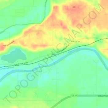
Name: Danes topographic map, elevation, terrain.

Location: Danes, Cass County, Indiana, United States (40.74115 -86.28111 40.78115 -86.24111)

Average elevation: 203 m

Minimum elevation: 180 m

Maximum elevation: 230 m

Other topographic maps

Click on a map to view its topography, its elevation and its terrain.

Galveston

United States > Indiana > Cass County

Average elevation: 246 m

Gear up for your next adventure:

🎒Fully Waterproof Backpack - Total protection for photography gear and electronics
🕯️Camping Lantern - Illuminates your entire campsite with high-efficiency LEDs
🕶️Polarized Sunglasses - Protect your eyes with durable polarized lenses
🩹Compact First Aid Kit - Pre-packed essentials for common trail injuries
💡Solar Camping Lamp - Eco-friendly lighting for campsites

As an Amazon Associate, this site earns from qualifying purchases at no extra cost to you.