Geolocate

Portage topographic map

Click on the map to display elevation.

About this map

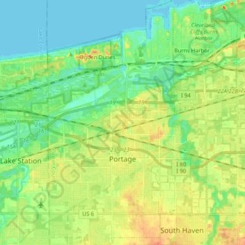
Name: Portage topographic map, elevation, terrain.

Location: Portage, Porter County, Indiana, United States (41.53604 -87.22256 41.64899 -87.12452)

Average elevation: 190 m

Minimum elevation: 175 m

Maximum elevation: 212 m

Other topographic maps

Click on a map to view its topography, its elevation and its terrain.

Carlson Lake

United States > Indiana > Porter County > Valparaiso

Average elevation: 250 m

Gear up for your next adventure:

🔦UV Flashlight - Detect minerals or specific insects in the dark
🛏️Sleeping Bag - Warm and compact sleeping bags for outdoor camping
🥾Trail Hiking Boots - Supportive boots for rough trails
🥾Waterproof Trail Shoes - Shoes designed to handle wet terrain
🧤Insulated Winter Gloves - Heavy-duty protection for sub-zero Canadian adventures

As an Amazon Associate, this site earns from qualifying purchases at no extra cost to you.