
Make a donation
Gear up for your next adventure:
As an Amazon Associate, this site earns from qualifying purchases at no extra cost to you.
Khandwa topographic map
Click on the map to display elevation.
Make a donation
Gear up for your next adventure:
As an Amazon Associate, this site earns from qualifying purchases at no extra cost to you.
About this map
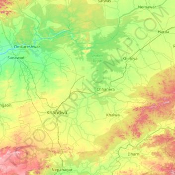
Name: Khandwa topographic map, elevation, terrain.
Location: Khandwa, Madhya Pradesh, India (21.54185 76.00974 22.41403 77.22118)
Average elevation: 323 m
Minimum elevation: 151 m
Maximum elevation: 785 m
Make a donation
Gear up for your next adventure:
As an Amazon Associate, this site earns from qualifying purchases at no extra cost to you.
Other topographic maps
Click on a map to view its topography, its elevation and its terrain.
Chanderi
India > Madhya Pradesh > Chanderi Tahsil
Chanderi is located at 24°43′N 78°08′E / 24.72°N 78.13°E / 24.72; 78.13. It has an average elevation of 456 metres (1496 feet).
Average elevation: 440 m
Balaghat
India > Madhya Pradesh > Balagat Tahsil
Balaghat is located at 21°48′N 80°11′E / 21.800°N 80.183°E / 21.800; 80.183. It has an average elevation of 288 metres (944 feet).
Average elevation: 304 m
Sehore
India > Madhya Pradesh > Sehore Nagar Tahsil
Sehore is 37 km from the state capital, Bhopal, towards the south-west and on the Bhopal - Indore highway. Its height from mean sea level is between 1500 ft. and 2000 ft. Sehore is situated on the Western Railway line from Bhopal to Ratlam. It is surrounded by 7 districts: Bhopal, Raisen, Harda, Hoshangabad,…
Average elevation: 501 m
Make a donation
Gear up for your next adventure:
As an Amazon Associate, this site earns from qualifying purchases at no extra cost to you.
Rewa
India > Madhya Pradesh > Huzur Tahsil
Rewa is located on 24°32′17″N 81°17′43″E / 24.53806°N 81.29528°E / 24.53806; 81.29528. It has an average elevation of 259 metres (853 feet). Rewa is situated on Bank of Bihad and Bichhiya river, it's on rewa pletaue sarounded with and vindhya and kaimur ranges .
Average elevation: 317 m
Damoh
India > Madhya Pradesh > Danyantinagar Tahsil
Damoh is located at 23°53′N 79°27′E / 23.88°N 79.45°E / 23.88; 79.45. It is at an average elevation of 595 metres (1,952 ft).
Average elevation: 362 m
Make a donation
Gear up for your next adventure:
As an Amazon Associate, this site earns from qualifying purchases at no extra cost to you.
Make a donation
Gear up for your next adventure:
As an Amazon Associate, this site earns from qualifying purchases at no extra cost to you.
Betma
India > Madhya Pradesh > Depalpur Tahsil
Betma is located at 22°41′N 75°37′E / 22.68°N 75.62°E / 22.68; 75.62. It has an average elevation of 541 metres (1774 feet).
Average elevation: 551 m
Make a donation
Gear up for your next adventure:
As an Amazon Associate, this site earns from qualifying purchases at no extra cost to you.
Make a donation
Gear up for your next adventure:
As an Amazon Associate, this site earns from qualifying purchases at no extra cost to you.
Shivpuri
India > Madhya Pradesh > Shivpuri NagarTahsil
Shivpuri is a city and a municipality in Shivpuri district located in the central Indian state of Madhya Pradesh. It is in the Gwalior Division of northwest Madhya Pradesh and is the administrative headquarters of Shivpuri District. It is situated at an altitude of 1,515 feet (462 m) above sea level.
Average elevation: 442 m
Make a donation
Gear up for your next adventure:
As an Amazon Associate, this site earns from qualifying purchases at no extra cost to you.
Make a donation
Gear up for your next adventure:
As an Amazon Associate, this site earns from qualifying purchases at no extra cost to you.
Make a donation
Gear up for your next adventure:
As an Amazon Associate, this site earns from qualifying purchases at no extra cost to you.
Sausar
India > Madhya Pradesh > Sausar Tahsil > Sausar
Sausar is located at 21°39′N 78°47′E / 21.65°N 78.78°E / 21.65; 78.78 in central India. It has an average elevation of 352 metres (1,154 feet). The Jam and Kanhan Rivers are the main rivers in Sausar. The city is situated between the two rivers.
Average elevation: 365 m
Sendhwa
India > Madhya Pradesh > Sendhwa Tahsil
Sendhwa is located at MH&MP Border 21°41′N 75°06′E / 21.68°N 75.1°E / 21.68; 75.1. It has an average elevation of 409 metres (1341 feet).
Average elevation: 409 m
Make a donation
Gear up for your next adventure:
As an Amazon Associate, this site earns from qualifying purchases at no extra cost to you.
Make a donation
Gear up for your next adventure:
As an Amazon Associate, this site earns from qualifying purchases at no extra cost to you.
Make a donation
Gear up for your next adventure:
As an Amazon Associate, this site earns from qualifying purchases at no extra cost to you.
Make a donation
Gear up for your next adventure:
As an Amazon Associate, this site earns from qualifying purchases at no extra cost to you.
Make a donation
Gear up for your next adventure:
As an Amazon Associate, this site earns from qualifying purchases at no extra cost to you.
Khachrod
India > Madhya Pradesh > Khacharod Tahsil
Khachrod is located at 23°25′N 75°17′E / 23.42°N 75.28°E / 23.42; 75.28. It sits at an elevation of 485 metres (1591 feet).
Average elevation: 497 m
Make a donation
Gear up for your next adventure:
As an Amazon Associate, this site earns from qualifying purchases at no extra cost to you.