
Make a donation
Gear up for your next adventure:
As an Amazon Associate, this site earns from qualifying purchases at no extra cost to you.
Sheep Island topographic map
Click on the map to display elevation.
Make a donation
Gear up for your next adventure:
As an Amazon Associate, this site earns from qualifying purchases at no extra cost to you.
About this map
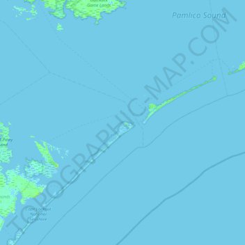
Name: Sheep Island topographic map, elevation, terrain.
Location: Sheep Island, Carteret County, North Carolina, United States (34.74944 -76.39222 35.38944 -75.75222)
Average elevation: 0 m
Minimum elevation: -2 m
Maximum elevation: 8 m
Make a donation
Gear up for your next adventure:
As an Amazon Associate, this site earns from qualifying purchases at no extra cost to you.
Other topographic maps
Click on a map to view its topography, its elevation and its terrain.
Make a donation
Gear up for your next adventure:
As an Amazon Associate, this site earns from qualifying purchases at no extra cost to you.
Wayne County
United States > North Carolina
Wayne County's surface is level to gently rolling uplands with broad bottoms along the rivers and some creeks. Elevations are predominantly 120 to 145 feet above sea level. The largest waterway, the Neuse River, bisects the lower central portion of the county and cuts a deep channel 20 to 40 feet deep as it…
Average elevation: 39 m
Make a donation
Gear up for your next adventure:
As an Amazon Associate, this site earns from qualifying purchases at no extra cost to you.
Stone Mountain State Park
United States > North Carolina > Wilkes County
The centerpiece of the park is Stone Mountain, a dome of exposed granite (specifically a quartz diorite to granodiorite) of Devonian age, which has intruded into the gneiss of the Precambrian Alligator Back Formation. It rises sharply over 600 feet (183 m) above the surrounding terrain. The mountain, which has…
Average elevation: 641 m
Newland
United States > North Carolina > Avery County
Newland is a town in Avery County, North Carolina, United States. The population was 698 at the 2010 census. It is the county seat of Avery County. It is the highest, by elevation, county seat east of the Mississippi River.
Average elevation: 1,140 m
Make a donation
Gear up for your next adventure:
As an Amazon Associate, this site earns from qualifying purchases at no extra cost to you.
Nash County
United States > North Carolina
Nash County rests in the northeastern part of North Carolina along the dividing line between the Peidmont and Coastal Plain regions. According to the U.S. Census Bureau, the county has a total area of 542.82 square miles (1,405.9 km2), of which 540.44 square miles (1,399.7 km2) is land and 2.38 square miles…
Average elevation: 59 m
Make a donation
Gear up for your next adventure:
As an Amazon Associate, this site earns from qualifying purchases at no extra cost to you.
Make a donation
Gear up for your next adventure:
As an Amazon Associate, this site earns from qualifying purchases at no extra cost to you.
Grandfather Mountain State Park
United States > North Carolina > Watauga County > Banner Elk
Grandfather Mountain rises 5,964 feet above sea level, and due to the considerable elevation gain the mountain boasts 16 distinct ecological communities. The mountain is famous for its rugged character, and is home to many hidden caves and significant cliffs.
Average elevation: 1,293 m
Make a donation
Gear up for your next adventure:
As an Amazon Associate, this site earns from qualifying purchases at no extra cost to you.
Sherrills Ford
United States > North Carolina > Catawba County
According to the United States Census Bureau, the CDP had a total area of 7.8 square miles (20 km2), 0.13% of which is water. It sits at an elevation of 204 m (670 ft).
Average elevation: 255 m
Beech Mountain
United States > North Carolina > Watauga County
Beech Mountain is a town in both Avery and Watauga counties in the U.S. state of North Carolina. As of the 2010 census, the town population was 320. The town is located atop Beech Mountain and is the highest town east of the Rocky Mountains at 5,506 ft (1,678 m) in elevation. The nearest municipality at a…
Average elevation: 1,267 m
West Jefferson
United States > North Carolina > Ashe County
West Jefferson is a popular destination among tourists and retirees from Florida, as well as those from the lower elevations of the Carolinas and Georgia.
Average elevation: 1,002 m
Make a donation
Gear up for your next adventure:
As an Amazon Associate, this site earns from qualifying purchases at no extra cost to you.
McDowell County
United States > North Carolina
Archaeological excavations performed by Dr. David Moore during the early 1980s, revealed artifacts and other evidence that the earliest inhabitants of McDowell County lived there from the Woodland period and Mississippian culture era, from 250 to 1500 AD. Dr. Moore discovered this material in an area close to…
Average elevation: 682 m
Make a donation
Gear up for your next adventure:
As an Amazon Associate, this site earns from qualifying purchases at no extra cost to you.
Pasquotank County
United States > North Carolina
Almost all of the terrain in Pasquotank County is flatland with a topography near sea level, a characteristic of most of North Carolina's Coastal Plain. The county is flanked by two rivers: the Pasquotank and the Little River.
Average elevation: 3 m
Gorges State Park
United States > North Carolina > Transylvania County
Following the flood, local citizens eventually sold large land tracts in the Gorges to Singer Sewing Machine Company, which logged most of the land. Then, in the 1940s and 1950s, Singer sold the land to Duke Energy Corporation. The corporation purchased the land for its steep topography and high rainfall,…
Average elevation: 682 m
Hanging Rock State Park
United States > North Carolina > Stokes County > Danbury
Hanging Rock State Park is located in the Sauratown Mountain Range, one of the most easterly mountain ranges in the state. Often called "the mountains away from the mountains," the Sauratown range is made up of monadnocks that are separated from the nearby Blue Ridge Mountains. The Sauratown Mountains lie…
Average elevation: 323 m
Make a donation
Gear up for your next adventure:
As an Amazon Associate, this site earns from qualifying purchases at no extra cost to you.
Eno River State Park
United States > North Carolina > Orange County
The Cox Mountain Trail is marked by blue blazes. The 3.75-mile (6.04 km) trail passes a picnic area and crosses the suspension foot bridge. The trail goes up 270 feet (82 m) in elevation and at one point follows Hillsborough Coach Road. When getting closer to Cox Mountain, the trail can get fairly steep. The…
Average elevation: 167 m
Make a donation
Gear up for your next adventure:
As an Amazon Associate, this site earns from qualifying purchases at no extra cost to you.
Make a donation
Gear up for your next adventure:
As an Amazon Associate, this site earns from qualifying purchases at no extra cost to you.
2388
United States > North Carolina > Yancey County > Burnsville
In addition to Mount Mitchell itself, the park encompasses several other peaks which top out at over 6,000 feet (1,800 m) in elevation, including Mount Hallback, Mount Craig (just 52 feet (16 m) shy of Mount Mitchell in elevation and the second highest peak east of the Mississippi River), Big Tom and Balsam…
Average elevation: 1,274 m
Make a donation
Gear up for your next adventure:
As an Amazon Associate, this site earns from qualifying purchases at no extra cost to you.
Henderson County
United States > North Carolina
Due to its geographic setting along the Eastern Continental Divide and its extreme topographic variation, Henderson County presents a wide variation in temperature and precipitation conditions. The highest elevations occur along the northwest and northern boundaries of the county and within the Blue Ridge…
Average elevation: 703 m
Saluda
United States > North Carolina > Polk County
Saluda is located in southwestern Polk County. Two small parts of the city extend west and north into Henderson County. The elevation on Main Street is 2,097 feet (639 m) above sea level, while the elevation at the bottom end of the Saluda Grade, in Tryon, is 1,080 feet (329.1 m).
Average elevation: 635 m
Make a donation
Gear up for your next adventure:
As an Amazon Associate, this site earns from qualifying purchases at no extra cost to you.
Make a donation
Gear up for your next adventure:
As an Amazon Associate, this site earns from qualifying purchases at no extra cost to you.
Zebulon
United States > North Carolina > Wake County
Zebulon is located in the northeast central region of North Carolina, where the North American Piedmont and Atlantic Coastal Plain regions meet. This area is known as the "Fall Line" because it marks the elevation inland at which waterfalls begin to appear in creeks and rivers. Its central Piedmont location…
Average elevation: 91 m
Make a donation
Gear up for your next adventure:
As an Amazon Associate, this site earns from qualifying purchases at no extra cost to you.
Franklin
United States > North Carolina > Franklin
Franklin is located at 35°10′52″N 83°22′54″W / 35.18111°N 83.38167°W / 35.18111; -83.38167 (35.181144, -83.381685). The elevation of Franklin is 2119 ft.
Average elevation: 675 m
Make a donation
Gear up for your next adventure:
As an Amazon Associate, this site earns from qualifying purchases at no extra cost to you.
Murphy
United States > North Carolina > Cherokee County
Murphy is located in southwestern North Carolina, approximately halfway between Atlanta, Georgia and Knoxville, Tennessee. The topography consists of gentle rolling hills and mountains with tall peaks, including ranges from 1800 ft to more than 5000 ft elevation. The location in the Blue Ridge Mountains has…
Average elevation: 514 m
Make a donation
Gear up for your next adventure:
As an Amazon Associate, this site earns from qualifying purchases at no extra cost to you.
Make a donation
Gear up for your next adventure:
As an Amazon Associate, this site earns from qualifying purchases at no extra cost to you.
Make a donation
Gear up for your next adventure:
As an Amazon Associate, this site earns from qualifying purchases at no extra cost to you.
Great Branch Meadow Branch
United States > North Carolina > Pitt County > Congleton
Average elevation: 17 m
Make a donation
Gear up for your next adventure:
As an Amazon Associate, this site earns from qualifying purchases at no extra cost to you.
Lansing
United States > North Carolina > Ashe County
Lansing is a popular destination among retirees and tourists from Florida, as well as those from the lower elevations of the Carolinas and Georgia.
Average elevation: 879 m
Alexander County
United States > North Carolina
Alexander County is located within the Foothills region of western North Carolina. The county's main geographic feature is the Brushy Mountains, a deeply eroded spur of the Blue Ridge Mountains to the west. The "Brushies," as they are called locally, rise from 300 to 1,000 feet (300 m) above the surrounding…
Average elevation: 364 m
Make a donation
Gear up for your next adventure:
As an Amazon Associate, this site earns from qualifying purchases at no extra cost to you.
Town of Pittsboro
United States > North Carolina > Chatham County > Town of Pittsboro
Average elevation: 123 m
Make a donation
Gear up for your next adventure:
As an Amazon Associate, this site earns from qualifying purchases at no extra cost to you.
Make a donation
Gear up for your next adventure:
As an Amazon Associate, this site earns from qualifying purchases at no extra cost to you.
Make a donation
Gear up for your next adventure:
As an Amazon Associate, this site earns from qualifying purchases at no extra cost to you.
Cherokee County
United States > North Carolina
Cherokee County is the westernmost county in the U.S. state of North Carolina. It borders Tennessee to its west and Georgia to its south. As of the 2020 census, the population was 28,774. The county seat is Murphy, elevation 1604 ft.
Average elevation: 655 m
Clay County
United States > North Carolina
Clay County is a county located in the far western part of U.S. state North Carolina. As of the 2020 census, the county population was 11,089. The county seat is Hayesville, elevation 1,893 ft.
Average elevation: 850 m
Make a donation
Gear up for your next adventure:
As an Amazon Associate, this site earns from qualifying purchases at no extra cost to you.