
Make a donation
Gear up for your next adventure:
As an Amazon Associate, this site earns from qualifying purchases at no extra cost to you.
Wayne County topographic map
Click on the map to display elevation.
Make a donation
Gear up for your next adventure:
As an Amazon Associate, this site earns from qualifying purchases at no extra cost to you.
Wayne County
Wayne County's surface is level to gently rolling uplands with broad bottoms along the rivers and some creeks. Elevations are predominantly 120 to 145 feet above sea level. The largest waterway, the Neuse River, bisects the lower central portion of the county and cuts a deep channel 20 to 40 feet deep as it flows in an eastward direction. Unusual river bluffs occur in the vicinity of Seven Springs. In addition to the Neuse River, the county is drained by the Little River, the Northeast Cape Fear River and numerous creeks.
Make a donation
Gear up for your next adventure:
As an Amazon Associate, this site earns from qualifying purchases at no extra cost to you.
About this map
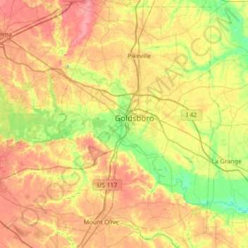
Name: Wayne County topographic map, elevation, terrain.
Location: Wayne County, North Carolina, United States (35.14880 -78.30658 35.59782 -77.79994)
Average elevation: 39 m
Minimum elevation: 7 m
Maximum elevation: 74 m
Make a donation
Gear up for your next adventure:
As an Amazon Associate, this site earns from qualifying purchases at no extra cost to you.
Other topographic maps
Click on a map to view its topography, its elevation and its terrain.
Arden
United States > North Carolina > Buncombe County > Asheville > Royal Pines
Average elevation: 693 m
Make a donation
Gear up for your next adventure:
As an Amazon Associate, this site earns from qualifying purchases at no extra cost to you.
Chimney Rock
United States > North Carolina > Rutherford County > Chimney Rock
Average elevation: 550 m
Make a donation
Gear up for your next adventure:
As an Amazon Associate, this site earns from qualifying purchases at no extra cost to you.
Make a donation
Gear up for your next adventure:
As an Amazon Associate, this site earns from qualifying purchases at no extra cost to you.
Make a donation
Gear up for your next adventure:
As an Amazon Associate, this site earns from qualifying purchases at no extra cost to you.
Carmel Commons
United States > North Carolina > Mecklenburg County > Charlotte
Average elevation: 174 m
Make a donation
Gear up for your next adventure:
As an Amazon Associate, this site earns from qualifying purchases at no extra cost to you.
Lincoln Heights
United States > North Carolina > Guilford County > Greensboro
Average elevation: 234 m
Make a donation
Gear up for your next adventure:
As an Amazon Associate, this site earns from qualifying purchases at no extra cost to you.
Make a donation
Gear up for your next adventure:
As an Amazon Associate, this site earns from qualifying purchases at no extra cost to you.
Make a donation
Gear up for your next adventure:
As an Amazon Associate, this site earns from qualifying purchases at no extra cost to you.
Make a donation
Gear up for your next adventure:
As an Amazon Associate, this site earns from qualifying purchases at no extra cost to you.
Make a donation
Gear up for your next adventure:
As an Amazon Associate, this site earns from qualifying purchases at no extra cost to you.
Make a donation
Gear up for your next adventure:
As an Amazon Associate, this site earns from qualifying purchases at no extra cost to you.
Dellwood Park
United States > North Carolina > Guilford County > Greensboro > Dellwood Park
Average elevation: 245 m
Make a donation
Gear up for your next adventure:
As an Amazon Associate, this site earns from qualifying purchases at no extra cost to you.
Make a donation
Gear up for your next adventure:
As an Amazon Associate, this site earns from qualifying purchases at no extra cost to you.
Lumberton
United States > North Carolina > Robeson County > Lumberton > Lumberton
Average elevation: 41 m
Make a donation
Gear up for your next adventure:
As an Amazon Associate, this site earns from qualifying purchases at no extra cost to you.
Hillcrest Farm
United States > North Carolina > Wayne County > Goldsboro > Hillcrest Farm
Average elevation: 34 m
Cumberland
United States > North Carolina > Guilford County > Greensboro > Cumberland
Average elevation: 244 m
Great Branch Meadow Branch
United States > North Carolina > Pitt County > Congleton
Average elevation: 17 m
Make a donation
Gear up for your next adventure:
As an Amazon Associate, this site earns from qualifying purchases at no extra cost to you.
North Brevard
United States > North Carolina > Transylvania County > North Brevard
Average elevation: 673 m
Boone
United States > North Carolina > Watauga County > Boone > Boone
Boone is located at 36°12′41″N 81°40′7″W / 36.21139°N 81.66861°W / 36.21139; -81.66861 (36.211364, −81.668657) and has an elevation of 3,333 feet (1015.9 m) above sea level. An earlier survey gave the elevation as 3,332 ft and since then it has been published as having an elevation of…
Average elevation: 977 m
Town of Pittsboro
United States > North Carolina > Chatham County > Town of Pittsboro
Average elevation: 123 m
Make a donation
Gear up for your next adventure:
As an Amazon Associate, this site earns from qualifying purchases at no extra cost to you.
Lake Christopher Apartments
United States > North Carolina > Cleveland County > Shelby
Average elevation: 260 m
Make a donation
Gear up for your next adventure:
As an Amazon Associate, this site earns from qualifying purchases at no extra cost to you.