
Make a donation
Gear up for your next adventure:
As an Amazon Associate, this site earns from qualifying purchases at no extra cost to you.
Henderson County topographic map
Click on the map to display elevation.
Make a donation
Gear up for your next adventure:
As an Amazon Associate, this site earns from qualifying purchases at no extra cost to you.
Henderson County
Due to its geographic setting along the Eastern Continental Divide and its extreme topographic variation, Henderson County presents a wide variation in temperature and precipitation conditions. The highest elevations occur along the northwest and northern boundaries of the county and within the Blue Ridge Escarpment, a rugged area of peaks and narrow valleys that rise from the Piedmont to the continental divide and the Blue Ridge Plateau. The lowest elevations occur within the valleys of the escarpment and in the broader valleys of the Blue Ridge Plateau. The mean annual temperature of the county is 55.1 °F, with a range from 50.3 to 57.9 °F depending on the elevation, with higher temperatures occurring at lower elevations and lower temperatures in the higher mountains. The month of July is the hottest in the county, with a mean temperature of 72.6 °F and a mean range of 66.6 to 75.8 °F. The coolest month is January with a mean temperature of 36.9 °F and a mean range of 33.3 to 39.5 °F. Precipitation is also correlated to elevation, with higher precipitation normally occurring at higher elevations and lower precipitation in the valleys. The mean annual precipitation of Henderson County is 56.2 inches, with a mean range of 45.04 to 78.03 inches. March has the highest mean precipitation of 5.1 inches, with a mean range of 3.9 to 6.7 inches. The lowest precipitation occurs in October, with a mean value of 3.9 inches and a mean range of 2.8 to 5.8 inches.
Make a donation
Gear up for your next adventure:
As an Amazon Associate, this site earns from qualifying purchases at no extra cost to you.
About this map
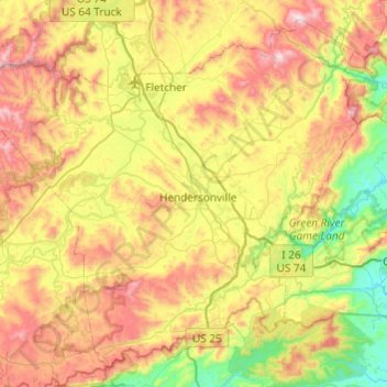
Name: Henderson County topographic map, elevation, terrain.
Location: Henderson County, North Carolina, United States (35.14419 -82.74515 35.50022 -82.26116)
Average elevation: 703 m
Minimum elevation: 276 m
Maximum elevation: 1,325 m
Make a donation
Gear up for your next adventure:
As an Amazon Associate, this site earns from qualifying purchases at no extra cost to you.
Other topographic maps
Click on a map to view its topography, its elevation and its terrain.
Arden
United States > North Carolina > Buncombe County > Asheville > Royal Pines
Average elevation: 693 m
Chimney Rock
United States > North Carolina > Rutherford County > Chimney Rock
Average elevation: 550 m
Make a donation
Gear up for your next adventure:
As an Amazon Associate, this site earns from qualifying purchases at no extra cost to you.
Make a donation
Gear up for your next adventure:
As an Amazon Associate, this site earns from qualifying purchases at no extra cost to you.
Make a donation
Gear up for your next adventure:
As an Amazon Associate, this site earns from qualifying purchases at no extra cost to you.
Lincoln Heights
United States > North Carolina > Guilford County > Greensboro
Average elevation: 234 m
Make a donation
Gear up for your next adventure:
As an Amazon Associate, this site earns from qualifying purchases at no extra cost to you.
Make a donation
Gear up for your next adventure:
As an Amazon Associate, this site earns from qualifying purchases at no extra cost to you.
Make a donation
Gear up for your next adventure:
As an Amazon Associate, this site earns from qualifying purchases at no extra cost to you.
Carmel Commons
United States > North Carolina > Mecklenburg County > Charlotte
Average elevation: 174 m
Make a donation
Gear up for your next adventure:
As an Amazon Associate, this site earns from qualifying purchases at no extra cost to you.
Make a donation
Gear up for your next adventure:
As an Amazon Associate, this site earns from qualifying purchases at no extra cost to you.
Make a donation
Gear up for your next adventure:
As an Amazon Associate, this site earns from qualifying purchases at no extra cost to you.
Make a donation
Gear up for your next adventure:
As an Amazon Associate, this site earns from qualifying purchases at no extra cost to you.
Make a donation
Gear up for your next adventure:
As an Amazon Associate, this site earns from qualifying purchases at no extra cost to you.
Dellwood Park
United States > North Carolina > Guilford County > Greensboro > Dellwood Park
Average elevation: 245 m
Make a donation
Gear up for your next adventure:
As an Amazon Associate, this site earns from qualifying purchases at no extra cost to you.
Make a donation
Gear up for your next adventure:
As an Amazon Associate, this site earns from qualifying purchases at no extra cost to you.
Lumberton
United States > North Carolina > Robeson County > Lumberton > Lumberton
Average elevation: 41 m
Make a donation
Gear up for your next adventure:
As an Amazon Associate, this site earns from qualifying purchases at no extra cost to you.
Hillcrest Farm
United States > North Carolina > Wayne County > Goldsboro > Hillcrest Farm
Average elevation: 34 m
Cumberland
United States > North Carolina > Guilford County > Greensboro > Cumberland
Average elevation: 244 m
Great Branch Meadow Branch
United States > North Carolina > Pitt County > Congleton
Average elevation: 17 m
Make a donation
Gear up for your next adventure:
As an Amazon Associate, this site earns from qualifying purchases at no extra cost to you.
North Brevard
United States > North Carolina > Transylvania County > North Brevard
Average elevation: 673 m
Boone
United States > North Carolina > Watauga County > Boone > Boone
Boone is located at 36°12′41″N 81°40′7″W / 36.21139°N 81.66861°W / 36.21139; -81.66861 (36.211364, −81.668657) and has an elevation of 3,333 feet (1015.9 m) above sea level. An earlier survey gave the elevation as 3,332 ft and since then it has been published as having an elevation of…
Average elevation: 977 m
Town of Pittsboro
United States > North Carolina > Chatham County > Town of Pittsboro
Average elevation: 123 m
Make a donation
Gear up for your next adventure:
As an Amazon Associate, this site earns from qualifying purchases at no extra cost to you.
Lake Christopher Apartments
United States > North Carolina > Cleveland County > Shelby
Average elevation: 260 m
Make a donation
Gear up for your next adventure:
As an Amazon Associate, this site earns from qualifying purchases at no extra cost to you.